1900-1909 Maps of Greene County, Ohio
Explore 5 historic maps of Greene County from 1900-1909. These maps offer a rare glimpse into what life looked like during the 1900s — showing old roads, neighborhoods, homes, and landmarks that have changed or disappeared over time.
Whether you're researching your family's past, planning a metal detecting trip, or studying how Greene County's landscape evolved across the 1900s, these high-resolution maps are a powerful tool for exploring the history of this region.
- Focus on a specific era: All maps on this page are from the 1900s, giving you a focused view of this time period.
- See what’s changed: Compare century-old streets, trails, and buildings to today's modern landscape using overlays and satellite layers.
- Research with precision: Use these maps for genealogy, historical research, land use analysis, or educational projects.
- View, download, or print: Maps are fully viewable online in high resolution, and can be downloaded or printed for your own records.
Start exploring Greene County's history through authentic maps from the 1900s. This is your window into the past.
Greene County, OH maps
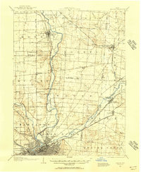
(5)- 1904 Map of Springfield, 1952 Print
 1904 Springfield1952 Print · USGSWest-central Ohio was a bustling network of electric railways and turnpikes at the opening of the twentieth century. Researchers can trace the early industrial footprint of Springfield or locate family roots near Yellow Springs, Pitchin, and the Masonic Home.2 unique versions available
 - 1904 Map of Dayton, 1956 Print
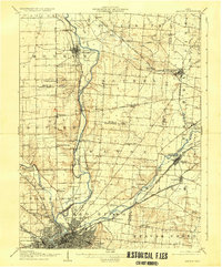
 1904 Dayton1956 Print · USGSThe Miami Valley at the dawn of the 1900s shows a landscape transformed by the Miami and Erie Canal and a dense network of interurban electric railways. Researchers can trace historic river communities like Osborn and Tipp City or follow the early path of the National Road.
 - 1906 Map of Dayton, 1935 Print
 1906 Dayton1935 Print · USGSThe Dayton region in the early twentieth century shows a landscape transitioning from the canal era to the age of electric interurbans and railroads. Trace the original sites of Osborn and Fairfield or locate the path of the Miami and Erie Canal.2 unique versions available
 - 1906 Map of Springfield, 1942 Print
 1906 Springfield1942 Print · USGSSpringfield and the surrounding Clark and Greene County townships are shown here during the peak era of electric traction and steam rail. Genealogists can trace family footprints through Ferncliff Cemetery, the Masonic Home, and settlements like Yellow Springs and Enon.
 - 1907 Map of South Charleston, 1943 Print
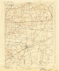 1907 South Charleston1943 Print · USGSThe Clark County countryside at the turn of the century shows a landscape dominated by rail travel and local school districts. Genealogists can locate family-named landmarks such as Yeazel School, Pancake Chapel, and the settlement of Dolly Varden.2 unique versions available
End of results
Showing maps 1-5 of 5
Top cities of Greene County
Frequently asked questions
- What are the different types of historical maps available for Greene County?
- What is the oldest map of Greene County?
- Where can I purchase historical maps of Greene County for my home or office?
- Where can I download high-res historical maps of Greene County?
- Are there historical topographic maps available for Greene County?
- Is there historical aerial imagery available for Greene County?
- Where are historical maps of Greene County sourced from?