1960s Maps of East End, Cincinnati
Explore 3 historic maps of East End from the 1960s. These maps offer a rare glimpse into what life looked like during the 1960s — showing old roads, neighborhoods, homes, and landmarks that have changed or disappeared over time.
Whether you're researching your family's past, planning a metal detecting trip, or studying how East End's landscape evolved across the 1960s, these high-resolution maps are a powerful tool for exploring the history of this region.
- Focus on a specific era: All maps on this page are from the 1960s, giving you a focused view of this time period.
- See what’s changed: Compare century-old streets, trails, and buildings to today's modern landscape using overlays and satellite layers.
- Research with precision: Use these maps for genealogy, historical research, land use analysis, or educational projects.
- View, download, or print: Maps are fully viewable online in high resolution, and can be downloaded or printed for your own records.
Start exploring East End's history through authentic maps from the 1960s. This is your window into the past.
East End, Cincinnati maps
(3)- 1961 Map of Covington, 1963 Print
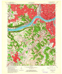 1961 Covington1963 Print · USGSThe Ohio River corridor comes alive in the early sixties as industrial centers and hillside neighborhoods bridge the state line. Genealogists and historians can trace St Josephs Cemetery, find the St Johns Orphanage, or locate the Anderson Ferry crossing.3 unique versions available
 - 1961 Map of Newport, 1963 Print
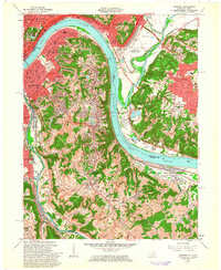 1961 Newport1963 Print · USGSGreater Cincinnati and Northern Kentucky were entering a period of suburban maturation in the early sixties as riverfront industry met rising hilltop neighborhoods. Researchers can trace local landmarks like Coney Island Amusement Park, Evergreen Cemetery, and the VA Hospital at Fort Thomas.3 unique versions available
 - 1961 Map of Cincinnati East, 1963 Print
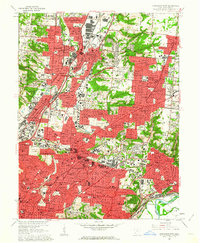 1961 Cincinnati East1963 Print · USGSGreater Cincinnati was entering a period of significant suburban expansion in the early sixties as industrial valleys met growing residential tracts. Researchers can trace family roots through numerous parish schools and sites like St Marys Cemetery, the University of Cincinnati Observatory, and the Baltimore and Ohio Railroad lines.6 unique versions available
End of results
Showing maps 1-3 of 3
Frequently asked questions
- What are the different types of historical maps available for East End?
- What is the oldest map of East End?
- Where can I purchase historical maps of East End for my home or office?
- Where can I download high-res historical maps of East End?
- Are there historical topographic maps available for East End?
- Is there historical aerial imagery available for East End?
- Where are historical maps of East End sourced from?