1940s Maps of Miami Township, Ohio
Explore 2 historic maps of Miami Township from the 1940s. These maps offer a rare glimpse into what life looked like during the 1940s — showing old roads, neighborhoods, homes, and landmarks that have changed or disappeared over time.
Whether you're researching your family's past, planning a metal detecting trip, or studying how Miami Township's landscape evolved across the 1940s, these high-resolution maps are a powerful tool for exploring the history of this region.
- Focus on a specific era: All maps on this page are from the 1940s, giving you a focused view of this time period.
- See what’s changed: Compare century-old streets, trails, and buildings to today's modern landscape using overlays and satellite layers.
- Research with precision: Use these maps for genealogy, historical research, land use analysis, or educational projects.
- View, download, or print: Maps are fully viewable online in high resolution, and can be downloaded or printed for your own records.
Start exploring Miami Township's history through authentic maps from the 1940s. This is your window into the past.
Miami Township, OH maps
(2)- 1943 Map of Hooven
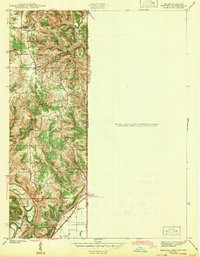 1943 Hooven1943 Print · USGSThe Indiana-Ohio borderlands come into focus in the early 1940s, showing a landscape defined by the Whitewater R and the New York Central rail line. Researchers can locate early family sites near Sugar Ridge Cem, the Full Gospel Mission, and the State Line Monument.
 - 1943 Map of Lawrenceburg
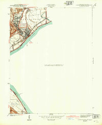 1943 Lawrenceburg1943 Print · USGSThe Indiana-Kentucky-Ohio tri-state border comes alive in this wartime-era survey of the Ohio River valley. Researchers can trace the rail-side growth of Lawrenceburg and Greendale or locate family plots in the Greendale Cem.
End of results
Showing maps 1-2 of 2
Top cities near Miami Township
- Cincinnati historical maps
- Hamilton historical maps
- Fairfield historical maps
- Covington historical maps
- Florence historical maps
- Independence historical maps
See more
Top neighborhoods of Miami Township
- Finney historical maps
- Miami Heights historical maps
- Gieringer historical maps
- Grandview historical maps
- Cleves historical maps
- Addyston historical maps
See more
Frequently asked questions
- What are the different types of historical maps available for Miami Township?
- What is the oldest map of Miami Township?
- Where can I purchase historical maps of Miami Township for my home or office?
- Where can I download high-res historical maps of Miami Township?
- Are there historical topographic maps available for Miami Township?
- Is there historical aerial imagery available for Miami Township?
- Where are historical maps of Miami Township sourced from?