1910s Maps of Hale Township, Ohio
Explore 2 historic maps of Hale Township from the 1910s. These maps offer a rare glimpse into what life looked like during the 1910s — showing old roads, neighborhoods, homes, and landmarks that have changed or disappeared over time.
Whether you're researching your family's past, planning a metal detecting trip, or studying how Hale Township's landscape evolved across the 1910s, these high-resolution maps are a powerful tool for exploring the history of this region.
- Focus on a specific era: All maps on this page are from the 1910s, giving you a focused view of this time period.
- See what’s changed: Compare century-old streets, trails, and buildings to today's modern landscape using overlays and satellite layers.
- Research with precision: Use these maps for genealogy, historical research, land use analysis, or educational projects.
- View, download, or print: Maps are fully viewable online in high resolution, and can be downloaded or printed for your own records.
Start exploring Hale Township's history through authentic maps from the 1910s. This is your window into the past.
Hale Township, OH maps
(2)- 1915 Map of Kenton, 1942 Print
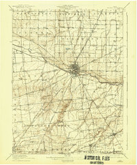 1915 Kenton1942 Print · USGSHardin County at the dawn of the motorized age shows a landscape deeply connected by competing rail lines and rural school districts. Genealogists and historians can trace family roots at dozens of named schoolhouses like Henpeck and Brush College, or locate vanished stops along the Toledo and Ohio Central Railroad.
 - 1915 Map of La Rue, 1944 Print
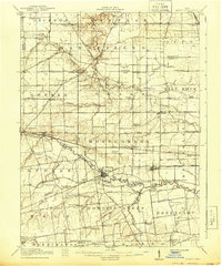 1915 La Rue1944 Print · USGSRailroad hubs and rural school districts define the landscape of Marion and Wyandot Counties in the years before the Great War. Genealogists can trace family roots through numerous local landmarks like York Street School, the village of La Rue, and the Scioto Military Land.
End of results
Showing maps 1-2 of 2
Top cities near Hale Township
- Bellefontaine historical maps
- Kenton historical maps
- Richwood historical maps
- Blanchard historical maps
- Belle Center historical maps
- La Rue historical maps
See more
Top neighborhoods of Hale Township
Frequently asked questions
- What are the different types of historical maps available for Hale Township?
- What is the oldest map of Hale Township?
- Where can I purchase historical maps of Hale Township for my home or office?
- Where can I download high-res historical maps of Hale Township?
- Are there historical topographic maps available for Hale Township?
- Is there historical aerial imagery available for Hale Township?
- Where are historical maps of Hale Township sourced from?