1960s Maps of Washington Township, Ohio
Explore 6 historic maps of Washington Township from the 1960s. These maps offer a rare glimpse into what life looked like during the 1960s — showing old roads, neighborhoods, homes, and landmarks that have changed or disappeared over time.
Whether you're researching your family's past, planning a metal detecting trip, or studying how Washington Township's landscape evolved across the 1960s, these high-resolution maps are a powerful tool for exploring the history of this region.
- Focus on a specific era: All maps on this page are from the 1960s, giving you a focused view of this time period.
- See what’s changed: Compare century-old streets, trails, and buildings to today's modern landscape using overlays and satellite layers.
- Research with precision: Use these maps for genealogy, historical research, land use analysis, or educational projects.
- View, download, or print: Maps are fully viewable online in high resolution, and can be downloaded or printed for your own records.
Start exploring Washington Township's history through authentic maps from the 1960s. This is your window into the past.
Washington Township, OH maps
(6)- 1961 Map of Foraker, 1962 Print
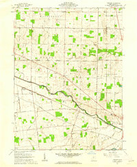 1961 Foraker1962 Print · USGSHardin County in the early sixties reveals a landscape shaped by the historical boundary of the Virginia Military District. Genealogists and historians can trace family-named sites like Smith Cem and landmarks such as the Friendship Grange Hall and Foraker.2 unique versions available
 - 1961 Map of Alger, 1962 Print
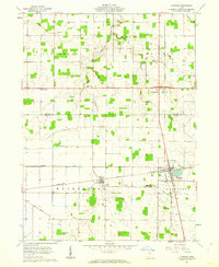
 1961 Alger1962 Print · USGSNorthwestern Hardin County thrived as a rail and drainage hub in the early sixties. Genealogists can trace family names at Carman Cem and Preston Cem or locate old community centers like Quickstep Ch and the village of McGuffey.2 unique versions available
 - 1961 Map of Dunkirk, 1962 Print
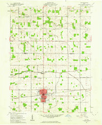
 1961 Dunkirk1962 Print · USGSIn the early 1960s, the border of Hancock and Hardin counties functioned as a busy rail crossroads and agricultural center. Local historians can trace the junction of the Pennsylvania and New York Central railroads at Dunkirk, alongside rural anchors like Hardin Northern Sch and Dola.2 unique versions available
 - 1961 Map of Ada, 1962 Print
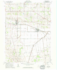
 1961 Ada1962 Print · USGSThe village of Ada and the campus of Ohio Northern University appear here in the early sixties as a center of education and rail transport. Researchers can trace family plots at McClure Cem and Thompson Cem or locate old rural landmarks like Liberty Chapel.2 unique versions available
 - 1962 Map of Marion
 1962 Marion1962 Print · USGSCentral Ohio during the post-war era showcases a dense network of railroad towns and emerging interstate highways. Genealogists can trace family roots in smaller settlements like Houcktown and Marseilles or locate landmarks near Indian Lake.
 - 1966 Map of Marion, 1968 Print
 1966 Marion1968 Print · USGSCentral Ohio in the mid-sixties is captured during a period of rapid highway expansion and industrial connectivity. Genealogists and historians can trace rail-and-river networks through towns like Marion, Urbana, and Mount Vernon, or locate landmarks such as Malabar Farm and Black Hand Rock.3 unique versions available
End of results
Showing maps 1-6 of 6
Top cities near Washington Township
- Findlay historical maps
- Kenton historical maps
- Ada historical maps
- Bluffton historical maps
- Blanchard historical maps
- Forest historical maps
See more
Top neighborhoods of Washington Township
Frequently asked questions
- What are the different types of historical maps available for Washington Township?
- What is the oldest map of Washington Township?
- Where can I purchase historical maps of Washington Township for my home or office?
- Where can I download high-res historical maps of Washington Township?
- Are there historical topographic maps available for Washington Township?
- Is there historical aerial imagery available for Washington Township?
- Where are historical maps of Washington Township sourced from?