1910s Maps of East Monroe, Ohio
Explore 1 historic maps of East Monroe from the 1910s. These maps offer a rare glimpse into what life looked like during the 1910s — showing old roads, neighborhoods, homes, and landmarks that have changed or disappeared over time.
Whether you're researching your family's past, planning a metal detecting trip, or studying how East Monroe's landscape evolved across the 1910s, these high-resolution maps are a powerful tool for exploring the history of this region.
- Focus on a specific era: All maps on this page are from the 1910s, giving you a focused view of this time period.
- See what’s changed: Compare century-old streets, trails, and buildings to today's modern landscape using overlays and satellite layers.
- Research with precision: Use these maps for genealogy, historical research, land use analysis, or educational projects.
- View, download, or print: Maps are fully viewable online in high resolution, and can be downloaded or printed for your own records.
Start exploring East Monroe's history through authentic maps from the 1910s. This is your window into the past.
East Monroe, OH maps
(1)- 1917 Map of Greenfield, 1937 Print
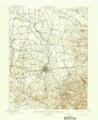 1917 Greenfield1937 Print · USGSSouthern Ohio at the start of the Great War was a network of rail-side towns and rural school districts. Genealogists can trace family roots through numerous local landmarks like Rock Mills, South Salem, and dozens of named schoolhouses such as Sunshine School.2 unique versions available
End of results
Showing maps 1-1 of 1
Top cities near East Monroe
- Washington Court House historical maps
- Hillsboro historical maps
- Greenfield historical maps
- Sabina historical maps
- New Market historical maps
- Leesburg historical maps
See more
Frequently asked questions
- What are the different types of historical maps available for East Monroe?
- What is the oldest map of East Monroe?
- Where can I purchase historical maps of East Monroe for my home or office?
- Where can I download high-res historical maps of East Monroe?
- Are there historical topographic maps available for East Monroe?
- Is there historical aerial imagery available for East Monroe?
- Where are historical maps of East Monroe sourced from?