1960s Maps of Hocking County, Ohio
Explore 17 historic maps of Hocking County from the 1960s. These maps offer a rare glimpse into what life looked like during the 1960s — showing old roads, neighborhoods, homes, and landmarks that have changed or disappeared over time.
Whether you're researching your family's past, planning a metal detecting trip, or studying how Hocking County's landscape evolved across the 1960s, these high-resolution maps are a powerful tool for exploring the history of this region.
- Focus on a specific era: All maps on this page are from the 1960s, giving you a focused view of this time period.
- See what’s changed: Compare century-old streets, trails, and buildings to today's modern landscape using overlays and satellite layers.
- Research with precision: Use these maps for genealogy, historical research, land use analysis, or educational projects.
- View, download, or print: Maps are fully viewable online in high resolution, and can be downloaded or printed for your own records.
Start exploring Hocking County's history through authentic maps from the 1960s. This is your window into the past.
Hocking County, OH maps
(17)- 1961 Map of Columbus
 1961 Columbus1961 Print · USGSCentral and Southern Ohio are captured here in the early sixties, as the region's industrial rail hubs and military bases reached their peak. Genealogists and historians can trace the transition from urban Columbus to rural townships along the Scioto River, locating Lockbourne USAF and old junctions like Washington Court House.
 - 1961 Map of Nelsonville, 1962 Print
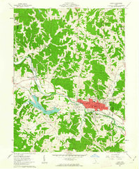
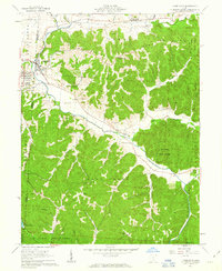
 1961 Nelsonville1962 Print · USGSThe Hocking River valley in the early sixties is a landscape of coal extraction and rail transport at the heart of the Wayne National Forest. Researchers can trace old family sites and mining history through labels like Carbon Hill, Oak Grove Ch, and several Strip Mine works.7 unique versions available
 - 1961 Map of New Straitsville, 1962 Print
 1961 New Straitsville1962 Print · USGSSoutheast Ohio's coal mining heartland is captured here in the early 1960s, showing a landscape shaped by deep hollows and active extraction. Genealogists can trace family sites at St Augustine Cem or locate former company towns like Carbon Hill and Jobs.6 unique versions available
 - 1961 Map of Clearport, 1963 Print
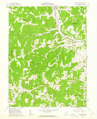
 1961 Clearport1963 Print · USGSFairfield County in the early sixties was a landscape of high ridges and rural crossroads where three counties meet. Genealogists can trace family names at Shaeffer Cemetery or Kern Cemetery, and locate old meeting houses like Hopewell Church and Morgan Chapel.4 unique versions available
 - 1961 Map of Gore, 1963 Print
 1961 Gore1963 Print · USGSHocking and Perry counties are shown here in the early sixties, where the industrial legacy of the Hocking Valley meets old land company boundaries. Genealogists and researchers can trace family sites at Webb Chapel Cem, Dawley Cem, and the old iron site at Bessie Furnace.3 unique versions available
 - 1961 Map of Union Furnace, 1963 Print
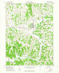
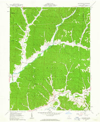
 1961 Union Furnace1963 Print · USGSThe Hocking River valley and the Wayne National Forest are captured here in the early sixties as coal mining and brick manufacturing shaped the landscape. Genealogists and historians can trace family sites at Morris Chapel Cem, the pottery town of Haydenville, and the remote mining camp at Carbondale.6 unique versions available
 - 1961 Map of New Plymouth, 1963 Print
 1961 New Plymouth1963 Print · USGSIn the early sixties, the Hocking-Vinton county line was a landscape of deep woods and active coal extraction. Genealogists and historians can locate family cemeteries like Strawn Cem and trace the rail path of the Chesapeake and Ohio through New Plymouth.4 unique versions available
 - 1961 Map of South Bloomingville, 1963 Print
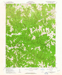 1961 South Bloomingville1963 Print · USGSThe Hocking Hills region in the early sixties was a landscape of deep hollows and forest camps at the height of its mid-century recreational development. Researchers can find numerous family cemeteries and remote landmarks like Old Baptist Cem, the Gold Mine near Huffine Hollow, and the Rock House Lookout Tower.4 unique versions available
 - 1961 Map of Logan, 1963 Print
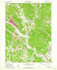
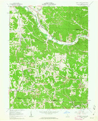
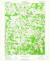
 1961 Logan1963 Print · USGSHocking County at the start of the 1960s shows a landscape defined by the winding Hocking River and the steady hum of the oil and rail industries. Researchers can locate family sites at Oak Grove Cemetery, the Marion Sch, or trace the old Chesapeake and Ohio rail corridor.4 unique versions available
 - 1961 Map of Bremen, 1963 Print
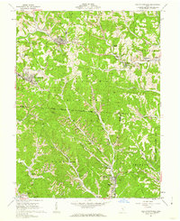
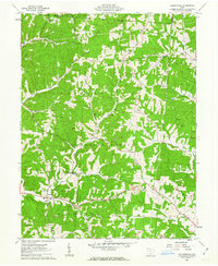
 1961 Bremen1963 Print · USGSThe rail-and-oil economy of Fairfield County is on full display in the early 1960s, centered on the village of Bremen. Trace family history through numerous rural sites like Swartz Mill, Mendonite Cem, and Olive Branch Ch scattered among the hills and creek valleys.3 unique versions available
 - 1961 Map of Laurelville, 1963 Print
 1961 Laurelville1963 Print · USGSLaurelville and Adelphi sat at the edge of the Ohio hill country in the early sixties, where farmland met deep forest. Genealogists can trace family landmarks like Schooley Cem and Bethel Ch or locate the ancient Indian Mound near the creek.4 unique versions available
 - 1961 Map of Ratcliffburg, 1963 Print
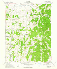
 1961 Ratcliffburg1963 Print · USGSThe hills of Vinton County in the early sixties reveal a landscape of deep hollows and isolated rural communities. Researchers can trace family sites at Ratcliffburg, locate the ancient Indian Mound, or find old burial grounds like the Slagle Farm Cem.3 unique versions available
 - 1961 Map of Allensville, 1963 Print
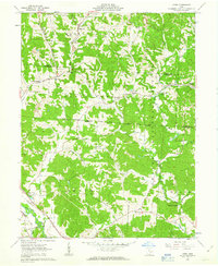
 1961 Allensville1963 Print · USGSVinton County’s heavily wooded ridges and deep hollows are captured here in the early sixties, showing a landscape of small hill-country settlements. Researchers can locate several family cemeteries like Stella Cem and landmarks such as the Covered Bridge near Allensville.4 unique versions available
 - 1961 Map of Rockbridge, 1963 Print
 1961 Rockbridge1963 Print · USGSThe Hocking River valley in the early sixties shows a landscape of deep hollows and ridge-top settlements. Genealogists can trace family names through numerous burial sites like Whippoorwill Cem and the Old Catholic Cem near Rockbridge.3 unique versions available
 - 1961 Map of Junction City, 1963 Print
 1961 Junction City1963 Print · USGSPerry County's industrial and rural character is on full display in the early 1960s, centered on the rail crossroads of Junction City. Genealogists can trace family names and sites like the Ohio State Penitentiary Branch, Old Zion Ch Cem, and Crossenville.3 unique versions available
 - 1962 Map of Columbus
 1962 Columbus1962 Print · USGSCentral Ohio during the early sixties reveals a transition from the industrial corridors of Columbus to the forested ridges of the south. Genealogists and historians can trace the rail networks of the Baltimore & Ohio RR and find local landmarks like Washington Court House and Camp Sherman Military Reservation.
 - 1967 Map of Columbus, 1969 Print
 1967 Columbus1969 Print · USGSCentral Ohio during the late sixties serves as a vital corridor of rail and aviation, from the industrial streets of Springfield to the hangar lines of Lockbourne Air Force Base. Genealogists and researchers can trace the growth of towns like Circleville and London or locate rural landmarks such as St Paul church and the London Correctional Institution.2 unique versions available
End of results
Showing maps 1-17 of 17
Top cities of Hocking County
Frequently asked questions
- What are the different types of historical maps available for Hocking County?
- What is the oldest map of Hocking County?
- Where can I purchase historical maps of Hocking County for my home or office?
- Where can I download high-res historical maps of Hocking County?
- Are there historical topographic maps available for Hocking County?
- Is there historical aerial imagery available for Hocking County?
- Where are historical maps of Hocking County sourced from?