1900-1909 Maps of Glade, Ohio
Explore 2 historic maps of Glade from 1900-1909. These maps offer a rare glimpse into what life looked like during the 1900s — showing old roads, neighborhoods, homes, and landmarks that have changed or disappeared over time.
Whether you're researching your family's past, planning a metal detecting trip, or studying how Glade's landscape evolved across the 1900s, these high-resolution maps are a powerful tool for exploring the history of this region.
- Focus on a specific era: All maps on this page are from the 1900s, giving you a focused view of this time period.
- See what’s changed: Compare century-old streets, trails, and buildings to today's modern landscape using overlays and satellite layers.
- Research with precision: Use these maps for genealogy, historical research, land use analysis, or educational projects.
- View, download, or print: Maps are fully viewable online in high resolution, and can be downloaded or printed for your own records.
Start exploring Glade's history through authentic maps from the 1900s. This is your window into the past.
Glade, OH maps
(2)- 1906 Map of Waverly
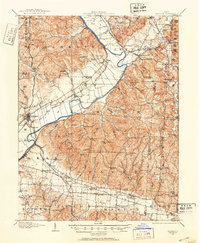 1906 Waverly1906 Print · USGSSouthern Ohio at the turn of the century shows a bustling corridor of river valleys and rail junctions centered on Waverly. Genealogists and historians can trace defunct post offices like Stony Creek Sta Pride PO and rural landmarks like Lilly Chapel or Cars Run School.
 - 1908 Map of Waverly, 1944 Print
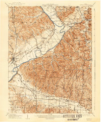 1908 Waverly1944 Print · USGSThe Scioto River valley at the start of the twentieth century was a vital crossroads of five competing railroads. Local historians can trace early mail stops like Robbins Dove PO and rural landmarks such as Lily Chapel or Meadow Run Church.
End of results
Showing maps 1-2 of 2
Top cities near Glade
- Jackson historical maps
- Wellston historical maps
- Waverly historical maps
- Piketon historical maps
- Richland historical maps
- Oak Hill historical maps
See more
Frequently asked questions
- What are the different types of historical maps available for Glade?
- What is the oldest map of Glade?
- Where can I purchase historical maps of Glade for my home or office?
- Where can I download high-res historical maps of Glade?
- Are there historical topographic maps available for Glade?
- Is there historical aerial imagery available for Glade?
- Where are historical maps of Glade sourced from?