1960s Maps of Fayette Township, Ohio
Explore 5 historic maps of Fayette Township from the 1960s. These maps offer a rare glimpse into what life looked like during the 1960s — showing old roads, neighborhoods, homes, and landmarks that have changed or disappeared over time.
Whether you're researching your family's past, planning a metal detecting trip, or studying how Fayette Township's landscape evolved across the 1960s, these high-resolution maps are a powerful tool for exploring the history of this region.
- Focus on a specific era: All maps on this page are from the 1960s, giving you a focused view of this time period.
- See what’s changed: Compare century-old streets, trails, and buildings to today's modern landscape using overlays and satellite layers.
- Research with precision: Use these maps for genealogy, historical research, land use analysis, or educational projects.
- View, download, or print: Maps are fully viewable online in high resolution, and can be downloaded or printed for your own records.
Start exploring Fayette Township's history through authentic maps from the 1960s. This is your window into the past.
Fayette Township, OH maps
(5)- 1960 Map of Huntington
 1960 Huntington1960 Print · USGSThe tri-state river valley thrived in the late fifties as a hub of heavy industry and Appalachian rail transit. Genealogists and historians can trace the connection between river towns like Ashland and Portsmouth or locate family homesteads near Coleman Ridge.
 - 1961 Map of Kitts Hill, 1963 Print
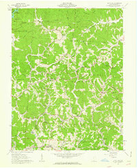 1961 Kitts Hill1963 Print · USGSThe ridges of southern Ohio appear as a network of small family farmsteads and forest lands in the early sixties. Genealogists can trace deep roots through dozens of family burial grounds and country churches like Oakland Chapel and Bazell Cem near Rock Camp.
 - 1961 Map of Aid, 1963 Print
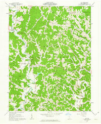 1961 Aid1963 Print · USGSLawrence County, Ohio, was a land of timbered ridges and coal mining during the early sixties. Genealogists can trace family roots through numerous remote burial sites like Gallicat Cem or visit the Covered Bridge near Scottown.
 - 1968 Map of Huntington, 1970 Print
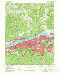 1968 Huntington1970 Print · USGSHuntington and the Ohio River valley reached a peak of industrial and rail connectivity during the late sixties. Genealogists and historians can trace family locations through Spring Hill Cemetery, numerous city schools like Buffington Sch, and the riverside rail networks of the B & O.4 unique versions available
 - 1968 Map of Catlettsburg, 1970 Print
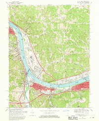 1968 Catlettsburg1970 Print · USGSThe tri-state junction of Kentucky, Ohio, and West Virginia is captured here in the late sixties at the busy confluence of the Big Sandy and Ohio Rivers. Researchers can trace the industrial footprint of Kenova and Catlettsburg or locate family sites like Sandhill Cem and Mt Pleasant Ch.3 unique versions available
End of results
Showing maps 1-5 of 5
Top cities near Fayette Township
- Huntington historical maps
- Ashland historical maps
- Ironton historical maps
- Rome historical maps
- Flatwoods historical maps
- South Point historical maps
See more
Top neighborhoods of Fayette Township
- Sulphur Springs historical maps
- Sunrise historical maps
- Essex historical maps
- Howell historical maps
- Burlington historical maps
- Hyland historical maps
See more
Frequently asked questions
- What are the different types of historical maps available for Fayette Township?
- What is the oldest map of Fayette Township?
- Where can I purchase historical maps of Fayette Township for my home or office?
- Where can I download high-res historical maps of Fayette Township?
- Are there historical topographic maps available for Fayette Township?
- Is there historical aerial imagery available for Fayette Township?
- Where are historical maps of Fayette Township sourced from?