1900-1909 Maps of Lorain County, Ohio
Explore 10 historic maps of Lorain County from 1900-1909. These maps offer a rare glimpse into what life looked like during the 1900s — showing old roads, neighborhoods, homes, and landmarks that have changed or disappeared over time.
Whether you're researching your family's past, planning a metal detecting trip, or studying how Lorain County's landscape evolved across the 1900s, these high-resolution maps are a powerful tool for exploring the history of this region.
- Focus on a specific era: All maps on this page are from the 1900s, giving you a focused view of this time period.
- See what’s changed: Compare century-old streets, trails, and buildings to today's modern landscape using overlays and satellite layers.
- Research with precision: Use these maps for genealogy, historical research, land use analysis, or educational projects.
- View, download, or print: Maps are fully viewable online in high resolution, and can be downloaded or printed for your own records.
Start exploring Lorain County's history through authentic maps from the 1900s. This is your window into the past.
Lorain County, OH maps
(10)- 1901 Map of Oberlin, 1952 Print
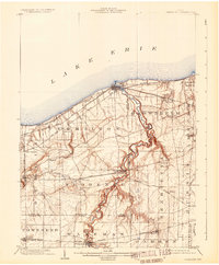
 1901 Oberlin1952 Print · USGSLorain County at the turn of the century shows a bustling corridor of electric interurbans and industrial sandstone quarries. Researchers can trace early railroad junctions at Elyria and Grafton, or locate lakeside settlements like Beach Park and Lake Breeze.3 unique versions available
 - 1902 Map of Berea, 1958 Print
 1902 Berea1958 Print · USGSCuyahoga and Lorain counties appear here at the turn of the century, when electric railways and steam lines were transforming small villages into bustling suburbs. Genealogists and local historians can trace family-named landmarks and early rail junctions in Berea, Olmsted Falls, and the lakeside community of Clifton Park.2 unique versions available
 - 1903 Map of Vermilion, 1932 Print
 1903 Vermilion1932 Print · USGSThe Lake Erie shoreline in the early twentieth century served as a vital transit hub where rail lines and electric cars converged on the coast. Genealogists and local historians can trace the early layouts of Vermilion, Wakeman, and Birmingham, or locate the specific placement of the Quarry and numerous creek-side homesteads.2 unique versions available
 - 1903 Map of Oberlin, 1943 Print
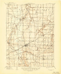
 1903 Oberlin1943 Print · USGSLorain County at the turn of the century is a hub of industrial growth and rail transit between the Lake Erie shore and the interior. Trace the complex web of electric lines and steam railroads connecting Lorain, Elyria, and Oberlin, or locate old stone Quarry sites near North Amherst and Grafton.
 - 1904 Map of Berea
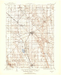
 1904 Berea1904 Print · USGSWestern Cuyahoga and northern Lorain counties are seen here at the start of the century as electric railways began connecting rural towns to the city. Trace the early streets of Olmsted Falls, the winding Rocky River, and vanished stops like Hardscrabble and Copopa.7 unique versions available
 - 1904 Map of Medina, 1954 Print
 1904 Medina1954 Print · USGSMedina and its surrounding townships are captured in the early 1900s, showing a landscape defined by the intersection of early pikes and competing steam and electric railroads. Genealogists can trace family connections in vanished stops and crossroads like River Styx, Abbeyville, and Sherman Corners.2 unique versions available
 - 1904 Map of Wellington, 1958 Print
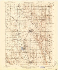
 1904 Wellington1958 Print · USGSNorth-central Ohio at the turn of the century is a network of growing rail towns and agricultural townships. Genealogists can trace family roots through settlements like Wellington, Homerville, and Lodi, while following the paths of the Wheeling and Lake Erie RR and Salt Creek.
 - 1906 Map of Medina, 1941 Print
 1906 Medina1941 Print · USGSIn Medina County at the dawn of the twentieth century, the rural landscape is a bustling network of electric rail lines and crossroads hamlets. Trace the early paths of the Cleveland Southwestern and Columbus Electric RR and find vanished rail stops like Lester or the community of River Styx.
 - 1906 Map of Wellington, 1942 Print
 1906 Wellington1942 Print · USGSNorth-central Ohio at the opening of the twentieth century was a landscape of thriving rail-junction towns and fertile creek bottoms. Genealogists and historians can trace the early footprints of Wellington, Sullivan, and Lodi as they were connected by the Baltimore and Ohio and several electric rail lines.
 - 1908 Map of New London, 1948 Print
 1908 New London1948 Print · USGSNorth-central Ohio at the turn of the century was a landscape of thriving rail junctions and rural school districts. Genealogists can trace family roots through numerous local landmarks like Barlams Store, Todd School, and the busy junction at New London.
End of results
Showing maps 1-10 of 10
Top cities of Lorain County
- Lorain historical maps
- Elyria historical maps
- North Ridgeville historical maps
- Avon historical maps
- Avon Lake historical maps
- Amherst historical maps
See more
Frequently asked questions
- What are the different types of historical maps available for Lorain County?
- What is the oldest map of Lorain County?
- Where can I purchase historical maps of Lorain County for my home or office?
- Where can I download high-res historical maps of Lorain County?
- Are there historical topographic maps available for Lorain County?
- Is there historical aerial imagery available for Lorain County?
- Where are historical maps of Lorain County sourced from?