1960s Maps of Mahoning County, Ohio
Explore 14 historic maps of Mahoning County from the 1960s. These maps offer a rare glimpse into what life looked like during the 1960s — showing old roads, neighborhoods, homes, and landmarks that have changed or disappeared over time.
Whether you're researching your family's past, planning a metal detecting trip, or studying how Mahoning County's landscape evolved across the 1960s, these high-resolution maps are a powerful tool for exploring the history of this region.
- Focus on a specific era: All maps on this page are from the 1960s, giving you a focused view of this time period.
- See what’s changed: Compare century-old streets, trails, and buildings to today's modern landscape using overlays and satellite layers.
- Research with precision: Use these maps for genealogy, historical research, land use analysis, or educational projects.
- View, download, or print: Maps are fully viewable online in high resolution, and can be downloaded or printed for your own records.
Start exploring Mahoning County's history through authentic maps from the 1960s. This is your window into the past.
Mahoning County, OH maps
(14)- 1960 Map of Deerfield, 1961 Print
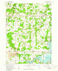 1960 Deerfield1961 Print · USGSPortage and Mahoning counties are captured here in the early sixties, as the local economy balanced farming with expanding industry. Genealogists and historians can locate several family burial sites like Whippoorwill Cem, the rail stop at Diamond, and the early reach of the Berlin Reservoir.4 unique versions available
 - 1962 Map of Canton
 1962 Canton1962 Print · USGSThe industrial heartland of Eastern Ohio and Western Pennsylvania thrives in the early sixties as steel mills and rail lines dominate the river valleys. Genealogists and historians can trace local landmarks like McKinley National Memorial, Malone College, and industrial sites such as Republic Steel Corp.2 unique versions available
 - 1962 Map of Cleveland
 1962 Cleveland1962 Print · USGSNortheast Ohio and the Pennsylvania borderlands appear here during the industrial peak of the early sixties. Genealogists and historians can trace the expansive rail lines of the Nickel Plate Road and the growth of suburbs from Parma to Lyndhurst.
 - 1962 Map of Columbiana, 1964 Print
 1962 Columbiana1964 Print · USGSNorth of the Mahoning and Columbiana county line during the early sixties, this region reveals a mix of industrial mining and new infrastructure. Trace family names at Mt Olivet Cem or locate former landmarks like Elser Airfield and St Marys Priory.3 unique versions available
 - 1962 Map of Sharon West, 1964 Print
 1962 Sharon West1964 Print · USGSThe industrial corridor of the Ohio-Pennsylvania state line comes alive in the early sixties as manufacturing hubs like Sharon and Farrell thrive. Researchers can trace family sites at St Patricks Cemetery or locate vanishing rail stops like Brookfield Station.4 unique versions available
 - 1962 Map of Girard, 1964 Print
 1962 Girard1964 Print · USGSThe Mahoning Valley steel corridor is captured here at its mid-century industrial peak. Genealogists and historians can trace family-named crossroads like Madden Corners and Hakes Corners or locate local landmarks like the Ursuline Convent and H C Mines Sch.4 unique versions available
 - 1963 Map of Campbell, 1964 Print
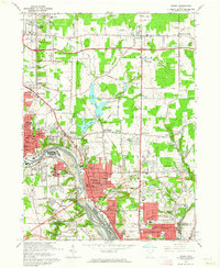
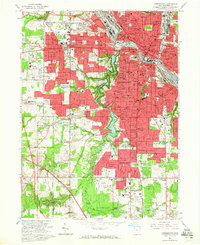
 1963 Campbell1964 Print · USGSThe Mahoning Valley industrial corridor reached a peak of rail and steel development during the early sixties. Genealogists can trace family roots through neighborhood landmarks like Scienceville, the Poland Cemetery, and many local schools from Reed Sch to Haddow Sch.3 unique versions available
 - 1963 Map of New Middletown, 1964 Print
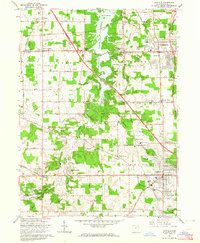
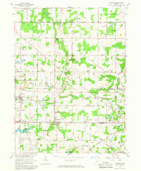
 1963 New Middletown1964 Print · USGSThe Mahoning County borderlands come into focus in the early sixties as major turnpikes began to reshape the rural landscape. Researchers can find family-named landmarks and essential community sites like Zion Cem, Bethel Ch, and Springfield Township High Sch.3 unique versions available
 - 1963 Map of Canfield, 1964 Print
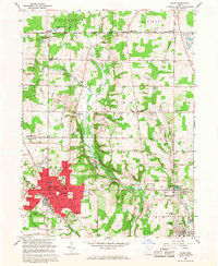
 1963 Canfield1964 Print · USGSMahoning County in the early sixties reveals a landscape balancing its agricultural roots with suburban growth. Genealogists and local historians can locate long-standing landmarks like St Pauls Monastery, the County Fairgrounds, and the Old North Cem.4 unique versions available
 - 1963 Map of Youngstown, 1965 Print
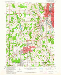
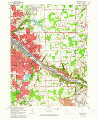
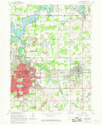
 1963 Youngstown1965 Print · USGSYoungstown was a thriving industrial hub in the mid-sixties, caught here at the peak of its rail-and-canal era. Researchers can trace family roots through numerous parish schools, major cemeteries like Calvary Cemetery, and the campus of Youngstown College.5 unique versions available
 - 1966 Map of Alliance, 1968 Print
 1966 Alliance1968 Print · USGSAlliance and its surrounding townships thrive in the mid-1960s as a vital rail and academic center. Researchers can trace the development of Mt Union College, identify family names at Hartzell Cem, or locate industry at the Strip Mines.3 unique versions available
 - 1966 Map of Damascus, 1968 Print
 1966 Damascus1968 Print · USGSNear the Mahoning and Columbiana county line in the mid-1960s, this area preserves the historic boundary of the Connecticut Western Reserve. Genealogists and researchers can trace the rail corridors of the Pennsylvania railroad and locate rural landmarks like Beech Ridge Church and Snodes.2 unique versions available
 - 1966 Map of Salem, 1968 Print
 1966 Salem1968 Print · USGSMid-century Columbiana County centers on the industrial hubs and rail junctions of the 1960s. Researchers can trace the legacy of regional transport and industry through the Penn Central line, coal mines near Millville, and the historic Salem Airpark.3 unique versions available
 - 1966 Map of Lake Milton, 1968 Print
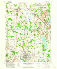
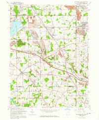
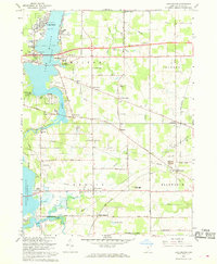 1966 Lake Milton1968 Print · USGSMahoning County is captured in the mid-1960s as lakeside recreation meets a traditional rail-and-river economy. Researchers can locate family roots at Vaughn Cem or trace the Penn Central tracks to Berlin Center Sta and Shiltown.2 unique versions available
End of results
Showing maps 1-14 of 14
Top cities of Mahoning County
- Youngstown historical maps
- Boardman historical maps
- Austintown historical maps
- Struthers historical maps
- Campbell historical maps
- Canfield historical maps
See more
Frequently asked questions
- What are the different types of historical maps available for Mahoning County?
- What is the oldest map of Mahoning County?
- Where can I purchase historical maps of Mahoning County for my home or office?
- Where can I download high-res historical maps of Mahoning County?
- Are there historical topographic maps available for Mahoning County?
- Is there historical aerial imagery available for Mahoning County?
- Where are historical maps of Mahoning County sourced from?