1960s Maps of Celina, Ohio
Explore 1 historic maps of Celina from the 1960s. These maps offer a rare glimpse into what life looked like during the 1960s — showing old roads, neighborhoods, homes, and landmarks that have changed or disappeared over time.
Whether you're researching your family's past, planning a metal detecting trip, or studying how Celina's landscape evolved across the 1960s, these high-resolution maps are a powerful tool for exploring the history of this region.
- Focus on a specific era: All maps on this page are from the 1960s, giving you a focused view of this time period.
- See what’s changed: Compare century-old streets, trails, and buildings to today's modern landscape using overlays and satellite layers.
- Research with precision: Use these maps for genealogy, historical research, land use analysis, or educational projects.
- View, download, or print: Maps are fully viewable online in high resolution, and can be downloaded or printed for your own records.
Start exploring Celina's history through authentic maps from the 1960s. This is your window into the past.
Celina, OH maps
(1)- 1960 Map of Celina, 1961 Print
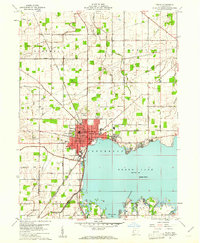 1960 Celina1961 Print · USGSMercer County life in the early sixties centers on the growing shoreline of Grand Lake and the hub of Celina. Trace historical family roots and old property lines using landmarks like North Grove Cemetery, Livingston PO, and the New York Chicago and St Louis RR.3 unique versions available
End of results
Showing maps 1-1 of 1
Top cities near Celina
- Saint Marys historical maps
- Coldwater historical maps
- New Bremen historical maps
- Minster historical maps
- St. Henry historical maps
- Spencerville historical maps
See more
Top neighborhoods of Celina
Frequently asked questions
- What are the different types of historical maps available for Celina?
- What is the oldest map of Celina?
- Where can I purchase historical maps of Celina for my home or office?
- Where can I download high-res historical maps of Celina?
- Are there historical topographic maps available for Celina?
- Is there historical aerial imagery available for Celina?
- Where are historical maps of Celina sourced from?