1920s Maps of Adams Township, Ohio
Explore 4 historic maps of Adams Township from the 1920s. These maps offer a rare glimpse into what life looked like during the 1920s — showing old roads, neighborhoods, homes, and landmarks that have changed or disappeared over time.
Whether you're researching your family's past, planning a metal detecting trip, or studying how Adams Township's landscape evolved across the 1920s, these high-resolution maps are a powerful tool for exploring the history of this region.
- Focus on a specific era: All maps on this page are from the 1920s, giving you a focused view of this time period.
- See what’s changed: Compare century-old streets, trails, and buildings to today's modern landscape using overlays and satellite layers.
- Research with precision: Use these maps for genealogy, historical research, land use analysis, or educational projects.
- View, download, or print: Maps are fully viewable online in high resolution, and can be downloaded or printed for your own records.
Start exploring Adams Township's history through authentic maps from the 1920s. This is your window into the past.
Adams Township, OH maps
(4)- 1924 Map of New Martinsville, 1956 Print
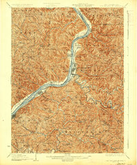
 1924 New Martinsville1956 Print · USGSThe Ohio River valley in the early twenties reveals a landscape of busy rail corridors and riverfront towns. Genealogists can locate family names and rural landmarks from Winders Mill to dozens of country schoolhouses like Democracy School and Wayne School.2 unique versions available
 - 1924 Map of New Matamoras, 1958 Print
 1924 New Matamoras1958 Print · USGSThe Ohio River borderlands are shown in detail during the mid-1920s, featuring the winding valleys of the Muskingum rivers. Genealogists can trace family locations through named schools and rural post offices like Rinard Mills, Salem Hall, and Zion Church.
 - 1926 Map of New Martinsville
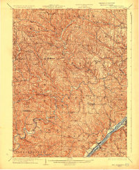
 1926 New Martinsville1926 Print · USGSThe Ohio River valley in the mid-1920s reveals a bustling corridor of rail and river commerce connecting New Martinsville and Sistersville. Genealogists can trace hundreds of rural landmarks, from the County Infirmary to isolated hill schools like Rothlisberger School and Sugar Valley School.2 unique versions available
 - 1926 Map of New Matamoras
 1926 New Matamoras1926 Print · USGSThe Ohio River valley and the rugged interior of Monroe County appear here in the mid-1920s. Genealogists can trace early twentieth-century rural life through numerous small post offices and schools like Cochransville Centerview PO and Excelsior School.2 unique versions available
End of results
Showing maps 1-4 of 4
Top cities near Adams Township
- New Martinsville historical maps
- Barnesville historical maps
- Woodsfield historical maps
- Sistersville historical maps
- Powhatan Point historical maps
- Malaga historical maps
See more
Top neighborhoods of Adams Township
Frequently asked questions
- What are the different types of historical maps available for Adams Township?
- What is the oldest map of Adams Township?
- Where can I purchase historical maps of Adams Township for my home or office?
- Where can I download high-res historical maps of Adams Township?
- Are there historical topographic maps available for Adams Township?
- Is there historical aerial imagery available for Adams Township?
- Where are historical maps of Adams Township sourced from?