1990s Maps of Adams Township, Ohio
Explore 4 historic maps of Adams Township from the 1990s. These maps offer a rare glimpse into what life looked like during the 1990s — showing old roads, neighborhoods, homes, and landmarks that have changed or disappeared over time.
Whether you're researching your family's past, planning a metal detecting trip, or studying how Adams Township's landscape evolved across the 1990s, these high-resolution maps are a powerful tool for exploring the history of this region.
- Focus on a specific era: All maps on this page are from the 1990s, giving you a focused view of this time period.
- See what’s changed: Compare century-old streets, trails, and buildings to today's modern landscape using overlays and satellite layers.
- Research with precision: Use these maps for genealogy, historical research, land use analysis, or educational projects.
- View, download, or print: Maps are fully viewable online in high resolution, and can be downloaded or printed for your own records.
Start exploring Adams Township's history through authentic maps from the 1990s. This is your window into the past.
Adams Township, OH maps
(4)- 1994 Map of Cameron, 1998 Print
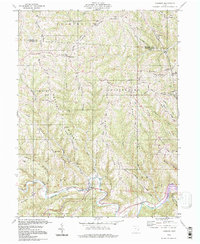 1994 Cameron1998 Print · USGSMonroe County’s high ridges and deep hollows are captured here in the late twentieth century, showing a landscape of persistent rural settlements. Genealogists can locate family-named landmarks like Pugh Ridge and old meeting houses such as Captain Ch or Mellott Ridge Ch.
 - 1994 Map of Round Bottom, 1998 Print
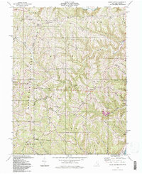 1994 Round Bottom1998 Print · USGSThe wooded ridges of Monroe County are shown here in the mid-1990s, where the Wayne National Forest meets the riverside towns of Hannibal and Sardis. Genealogists and historians can trace numerous rural landmarks, from Chapel Hill Ch to the McIntire Cem and the small settlement at Round Bottom.
 - 1994 Map of Antioch, 1998 Print
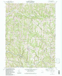 1994 Antioch1998 Print · USGSMonroe County, Ohio, remains defined by its deep ridges and the winding path of the Little Muskingum River during the late twentieth century. Genealogists can trace family landmarks and rural life through Moffets Ch, Haythorn Cem, and the settlement of Antioch.
 - 1994 Map of Woodsfield, 1998 Print
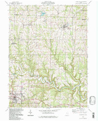 1994 Woodsfield1998 Print · USGSMonroe County hills in the late twentieth century show a landscape of high ridge settlements and deep creek hollows. Genealogists can trace family landmarks like Asbury Chapel Cem, Harmon Cem, and the old County Home near Woodsfield.
End of results
Showing maps 1-4 of 4
Top cities near Adams Township
- New Martinsville historical maps
- Barnesville historical maps
- Woodsfield historical maps
- Sistersville historical maps
- Powhatan Point historical maps
- Malaga historical maps
See more
Top neighborhoods of Adams Township
Frequently asked questions
- What are the different types of historical maps available for Adams Township?
- What is the oldest map of Adams Township?
- Where can I purchase historical maps of Adams Township for my home or office?
- Where can I download high-res historical maps of Adams Township?
- Are there historical topographic maps available for Adams Township?
- Is there historical aerial imagery available for Adams Township?
- Where are historical maps of Adams Township sourced from?