1960s Maps of Jackson Township, Ohio
Explore 5 historic maps of Jackson Township from the 1960s. These maps offer a rare glimpse into what life looked like during the 1960s — showing old roads, neighborhoods, homes, and landmarks that have changed or disappeared over time.
Whether you're researching your family's past, planning a metal detecting trip, or studying how Jackson Township's landscape evolved across the 1960s, these high-resolution maps are a powerful tool for exploring the history of this region.
- Focus on a specific era: All maps on this page are from the 1960s, giving you a focused view of this time period.
- See what’s changed: Compare century-old streets, trails, and buildings to today's modern landscape using overlays and satellite layers.
- Research with precision: Use these maps for genealogy, historical research, land use analysis, or educational projects.
- View, download, or print: Maps are fully viewable online in high resolution, and can be downloaded or printed for your own records.
Start exploring Jackson Township's history through authentic maps from the 1960s. This is your window into the past.
Jackson Township, OH maps
(5)- 1960 Map of Antioch, 1961 Print
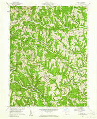 1960 Antioch1961 Print · USGSMonroe County was a landscape of deep timber and winding valley roads in the early sixties. Genealogists and hikers can trace the paths between Antioch, Mechanicsburg, and Fletchers Chapel, or locate old burial sites like Old Otts Cem.4 unique versions available
 - 1960 Map of Paden City, 1961 Print
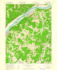 1960 Paden City1961 Print · USGSThe Ohio River valley thrives in the early sixties as a hub of industry and rail. Genealogists can trace family roots at Kidwell Ch, Stender Cem, and the riverfront communities of Paden City and Sistersville.4 unique versions available
 - 1960 Map of Round Bottom, 1962 Print
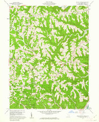 1960 Round Bottom1962 Print · USGSThe Ohio River hills of Monroe County are shown here in the early sixties, a landscape of ridge-top farms and river towns. Researchers can trace family history through sites like Winklers Mill, Emma Grove Cem, and the interior settlement of Round Bottom.4 unique versions available
 - 1960 Map of New Matamoras, 1962 Print
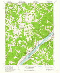 1960 New Matamoras1962 Print · USGSThe Ohio River valley was a thriving industrial and transport corridor in the early sixties, anchored by the riverfront centers of Sistersville and New Matamoras. Trace the old Baltimore and Ohio rail line, find ridge-top settlements like Jericho, or locate rural landmarks like Friendly Ch.4 unique versions available
 - 1961 Map of Clarksburg
 1961 Clarksburg1961 Print · USGSThe mid-century industrial and river landscapes of West Virginia and Ohio are detailed here, centered on the Ohio River. Researchers can trace the Baltimore and Ohio rail lines connecting towns like Parkersburg, Clarksburg, and Monongah.
End of results
Showing maps 1-5 of 5
Top cities near Jackson Township
- New Martinsville historical maps
- Woodsfield historical maps
- Grandview historical maps
- Sistersville historical maps
- New Matamoras historical maps
- Middlebourne historical maps
See more
Top neighborhoods of Jackson Township
Frequently asked questions
- What are the different types of historical maps available for Jackson Township?
- What is the oldest map of Jackson Township?
- Where can I purchase historical maps of Jackson Township for my home or office?
- Where can I download high-res historical maps of Jackson Township?
- Are there historical topographic maps available for Jackson Township?
- Is there historical aerial imagery available for Jackson Township?
- Where are historical maps of Jackson Township sourced from?