1960s Maps of Montgomery County, Ohio
Explore 13 historic maps of Montgomery County from the 1960s. These maps offer a rare glimpse into what life looked like during the 1960s — showing old roads, neighborhoods, homes, and landmarks that have changed or disappeared over time.
Whether you're researching your family's past, planning a metal detecting trip, or studying how Montgomery County's landscape evolved across the 1960s, these high-resolution maps are a powerful tool for exploring the history of this region.
- Focus on a specific era: All maps on this page are from the 1960s, giving you a focused view of this time period.
- See what’s changed: Compare century-old streets, trails, and buildings to today's modern landscape using overlays and satellite layers.
- Research with precision: Use these maps for genealogy, historical research, land use analysis, or educational projects.
- View, download, or print: Maps are fully viewable online in high resolution, and can be downloaded or printed for your own records.
Start exploring Montgomery County's history through authentic maps from the 1960s. This is your window into the past.
Montgomery County, OH maps
(13)- 1960 Map of Farmersville, 1962 Print
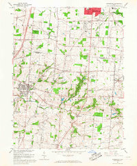
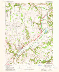
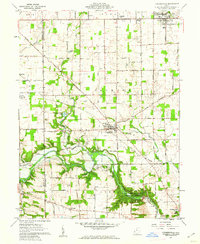 1960 Farmersville1962 Print · USGSFarmersville and western Montgomery County appear in the early 1960s as a landscape of productive farmsteads and managed river valleys. Researchers can trace rural life via the Township Sch, family-named roads like Moses Road, and the Germantown Dam.4 unique versions available
 - 1961 Map of Laura, 1962 Print
 1961 Laura1962 Print · USGSWestern Ohio farm country and quiet crossroads villages thrive in the early sixties across this multi-county border. Genealogists can trace family names through Mote Cem and Swank Cem or locate old homesteads near Potsdam and Pittsburg.2 unique versions available
 - 1961 Map of Brookville, 1962 Print
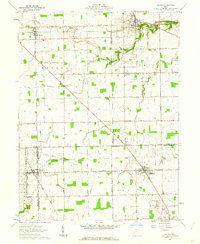
 1961 Brookville1962 Print · USGSBrookville and the surrounding townships of Montgomery and Preble counties appear here in the early 1960s as the regional rail and road networks matured. Genealogists can locate family sites near Wolf Creek Ch, Pleasant Hill Cem, and the crossroads at Pyrmont.3 unique versions available
 - 1965 Map of Franklin, 1967 Print
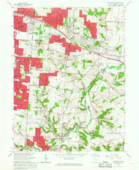
 1965 Franklin1967 Print · USGSMiddletown and Franklin thrive along the river and rail corridors of the Miami Valley in the mid-1960s. Genealogists and researchers can trace local landmarks like Wood Hill Cemetery, Stettler Ch, and the sprawling Mound Laboratory (AEC) complex.5 unique versions available
 - 1965 Map of Dayton North, 1967 Print
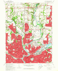 1965 Dayton North1967 Print · USGSDayton and its northern suburbs underwent rapid mid-century growth where the Great Miami and Mad Rivers meet. Researchers can trace the development of Huber Heights, locate the Siena Sisters of Mercy Rest Home, or find early sites like Poplar Hill Cem.5 unique versions available
 - 1965 Map of Tipp City, 1967 Print
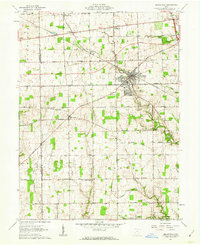
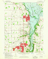 1965 Tipp City1967 Print · USGSMiami County's river valley transition is captured here in the mid-sixties as Vandalia and Tipp City expand toward the Dayton Municipal Airport. Researchers can trace old family landmarks and rural hubs like Pearson Cem, Ginghamsburg, and the Middle District Sch.4 unique versions available
 - 1965 Map of Fairborn, 1967 Print
 1965 Fairborn1967 Print · USGSThe Dayton suburbs and Fairborn area undergo rapid postwar expansion during the mid-sixties, centered on the massive Wright-Patterson Air Force Base. Researchers can trace the early layout of Wright State University and vanished rail stops along the Erie Lackawanna.6 unique versions available
 - 1965 Map of Miamisburg, 1967 Print
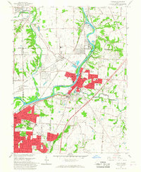
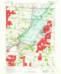
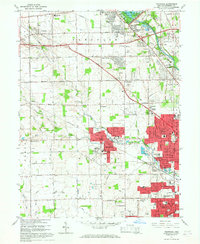
 1965 Miamisburg1967 Print · USGSThe Great Miami River valley in the mid-sixties shows a landscape of industrial growth and rural tradition south of Dayton. Researchers can locate family roots at Highland Memorial Cemetery, trace the old rail lines, or find the Mound Laboratory near the Miamisburg Mound State Memorial.4 unique versions available
 - 1965 Map of Springboro, 1967 Print
 1965 Springboro1967 Print · USGSThe Montgomery and Warren County line comes alive in the mid-sixties as Centerville and Springboro begin to expand. Researchers can trace family history through sites like Rehoboth Cem, Bethel Ch, and the crossroads at Five Points.4 unique versions available
 - 1965 Map of Trotwood, 1967 Print
 1965 Trotwood1967 Print · USGSWest of Dayton in the mid-sixties, this area shows a landscape transitioning from family farms to suburban developments. Genealogists and local historians can trace legacy sites like Cedar Hill Cem, Dahio Airfield, and the notable Precious Blood Convent.5 unique versions available
 - 1965 Map of Bellbrook, 1967 Print
 1965 Bellbrook1967 Print · USGSGreene and Montgomery Counties are captured during a period of suburban transition in the mid-1960s. Researchers can locate family landmarks like the Pioneer Cem, the historic Covered Bridge, and old schoolhouses including Bell Sch.5 unique versions available
 - 1966 Map of Dayton South, 1968 Print
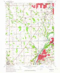
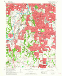 1966 Dayton South1968 Print · USGSThe southern suburbs of Montgomery County were rapidly expanding in the mid-sixties as Dayton reached into the surrounding hills. Researchers can trace institutional history and family locations at the Dayton State Hospital, Calvary Cemetery, and the Gentile AF Depot.5 unique versions available
 - 1968 Map of Waynesville, 1970 Print
 1968 Waynesville1970 Print · USGSThe Little Miami River valley in the late sixties shows a landscape of established river towns and expanding conservation areas. Genealogists can trace family landmarks and burial sites like Miami Cemetery, Roxanna, and the village of Waynesville.3 unique versions available
End of results
Showing maps 1-13 of 13
Top cities of Montgomery County
- Dayton historical maps
- Kettering historical maps
- Huber Heights historical maps
- Trotwood historical maps
- Centerville historical maps
- Riverside historical maps
See more
Frequently asked questions
- What are the different types of historical maps available for Montgomery County?
- What is the oldest map of Montgomery County?
- Where can I purchase historical maps of Montgomery County for my home or office?
- Where can I download high-res historical maps of Montgomery County?
- Are there historical topographic maps available for Montgomery County?
- Is there historical aerial imagery available for Montgomery County?
- Where are historical maps of Montgomery County sourced from?