1960s Maps of New Lebanon, Ohio
Explore 4 historic maps of New Lebanon from the 1960s. These maps offer a rare glimpse into what life looked like during the 1960s — showing old roads, neighborhoods, homes, and landmarks that have changed or disappeared over time.
Whether you're researching your family's past, planning a metal detecting trip, or studying how New Lebanon's landscape evolved across the 1960s, these high-resolution maps are a powerful tool for exploring the history of this region.
- Focus on a specific era: All maps on this page are from the 1960s, giving you a focused view of this time period.
- See what’s changed: Compare century-old streets, trails, and buildings to today's modern landscape using overlays and satellite layers.
- Research with precision: Use these maps for genealogy, historical research, land use analysis, or educational projects.
- View, download, or print: Maps are fully viewable online in high resolution, and can be downloaded or printed for your own records.
Start exploring New Lebanon's history through authentic maps from the 1960s. This is your window into the past.
New Lebanon, OH maps
(4)- 1960 Map of Farmersville, 1962 Print
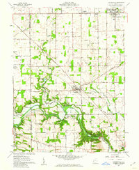 1960 Farmersville1962 Print · USGSFarmersville and western Montgomery County appear in the early 1960s as a landscape of productive farmsteads and managed river valleys. Researchers can trace rural life via the Township Sch, family-named roads like Moses Road, and the Germantown Dam.4 unique versions available
 - 1961 Map of Brookville, 1962 Print
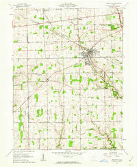 1961 Brookville1962 Print · USGSBrookville and the surrounding townships of Montgomery and Preble counties appear here in the early 1960s as the regional rail and road networks matured. Genealogists can locate family sites near Wolf Creek Ch, Pleasant Hill Cem, and the crossroads at Pyrmont.3 unique versions available
 - 1965 Map of Miamisburg, 1967 Print
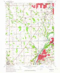 1965 Miamisburg1967 Print · USGSThe Great Miami River valley in the mid-sixties shows a landscape of industrial growth and rural tradition south of Dayton. Researchers can locate family roots at Highland Memorial Cemetery, trace the old rail lines, or find the Mound Laboratory near the Miamisburg Mound State Memorial.4 unique versions available
 - 1965 Map of Trotwood, 1967 Print
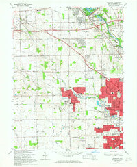 1965 Trotwood1967 Print · USGSWest of Dayton in the mid-sixties, this area shows a landscape transitioning from family farms to suburban developments. Genealogists and local historians can trace legacy sites like Cedar Hill Cem, Dahio Airfield, and the notable Precious Blood Convent.5 unique versions available
End of results
Showing maps 1-4 of 4
Top cities near New Lebanon
- Dayton historical maps
- Kettering historical maps
- Middletown historical maps
- Huber Heights historical maps
- Trotwood historical maps
- Centerville historical maps
See more
Top neighborhoods of New Lebanon
Frequently asked questions
- What are the different types of historical maps available for New Lebanon?
- What is the oldest map of New Lebanon?
- Where can I purchase historical maps of New Lebanon for my home or office?
- Where can I download high-res historical maps of New Lebanon?
- Are there historical topographic maps available for New Lebanon?
- Is there historical aerial imagery available for New Lebanon?
- Where are historical maps of New Lebanon sourced from?