1910s Maps of Muskingum County, Ohio
Explore 6 historic maps of Muskingum County from the 1910s. These maps offer a rare glimpse into what life looked like during the 1910s — showing old roads, neighborhoods, homes, and landmarks that have changed or disappeared over time.
Whether you're researching your family's past, planning a metal detecting trip, or studying how Muskingum County's landscape evolved across the 1910s, these high-resolution maps are a powerful tool for exploring the history of this region.
- Focus on a specific era: All maps on this page are from the 1910s, giving you a focused view of this time period.
- See what’s changed: Compare century-old streets, trails, and buildings to today's modern landscape using overlays and satellite layers.
- Research with precision: Use these maps for genealogy, historical research, land use analysis, or educational projects.
- View, download, or print: Maps are fully viewable online in high resolution, and can be downloaded or printed for your own records.
Start exploring Muskingum County's history through authentic maps from the 1910s. This is your window into the past.
Muskingum County, OH maps
(6)- 1910 Map of Frazeysburg, 1937 Print
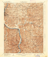
 1910 Frazeysburg1937 Print · USGSMuskingum and Licking Counties are captured here during a pivotal era of rail dominance and canal obsolescence. Researchers can locate vanished rural schoolhouses like Pisgah School or trace the early paths of the Ohio Canal near Dresden.2 unique versions available
 - 1910 Map of Philo, 1938 Print
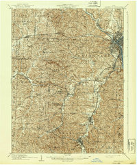
 1910 Philo1938 Print · USGSThe Muskingum River valley was a bustling corridor of rail and river commerce at the turn of the century. Genealogists can locate dozens of country schoolhouses like Toadtown School and Sleepy Hollow School, or trace family roots near Taylorsville and the National Road.2 unique versions available
 - 1910 Map of Zanesville, 1939 Print
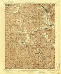
 1910 Zanesville1939 Print · USGSMuskingum and Perry counties are shown here in the early twentieth century as Zanesville emerged as a powerhouse of rail and river commerce. Researchers can trace historic transport routes like the National Road or locate local landmarks such as Moxahala Park and the Fultonham (Axline PO).2 unique versions available
 - 1910 Map of Conesville, 1948 Print
 1910 Conesville1948 Print · USGSThe Muskingum River valley and the Ohio Canal are captured here in the decade before the Great War. Genealogists can trace family homesteads near dozens of rural landmarks like Young America School, Otsego, and Munroe Basin.
 - 1911 Map of Cumberland, 1939 Print
 1911 Cumberland1939 Print · USGSSoutheastern Ohio at the start of the twentieth century was a landscape of ridge-top schools and valley rail junctions. Genealogists can trace family footprints through dozens of rural landmarks like Goshen Church, Dogtown, and the Rough and Ready School.2 unique versions available
 - 1912 Map of Cambridge, 1946 Print
 1912 Cambridge1946 Print · USGSGuernsey County was a bustling hub of rail and river commerce at the start of the century. You can trace the path of the National Road and locate family landmarks like Barnes Mill, Zion Church, and dozens of district schools.2 unique versions available
End of results
Showing maps 1-6 of 6
Top cities of Muskingum County
- Zanesville historical maps
- Hopewell historical maps
- New Concord historical maps
- South Zanesville historical maps
- Dresden historical maps
- Brush Creek historical maps
See more
Frequently asked questions
- What are the different types of historical maps available for Muskingum County?
- What is the oldest map of Muskingum County?
- Where can I purchase historical maps of Muskingum County for my home or office?
- Where can I download high-res historical maps of Muskingum County?
- Are there historical topographic maps available for Muskingum County?
- Is there historical aerial imagery available for Muskingum County?
- Where are historical maps of Muskingum County sourced from?