1990s Maps of Muskingum County, Ohio
Explore 17 historic maps of Muskingum County from the 1990s. These maps offer a rare glimpse into what life looked like during the 1990s — showing old roads, neighborhoods, homes, and landmarks that have changed or disappeared over time.
Whether you're researching your family's past, planning a metal detecting trip, or studying how Muskingum County's landscape evolved across the 1990s, these high-resolution maps are a powerful tool for exploring the history of this region.
- Focus on a specific era: All maps on this page are from the 1990s, giving you a focused view of this time period.
- See what’s changed: Compare century-old streets, trails, and buildings to today's modern landscape using overlays and satellite layers.
- Research with precision: Use these maps for genealogy, historical research, land use analysis, or educational projects.
- View, download, or print: Maps are fully viewable online in high resolution, and can be downloaded or printed for your own records.
Start exploring Muskingum County's history through authentic maps from the 1990s. This is your window into the past.
Muskingum County, OH maps
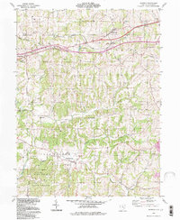
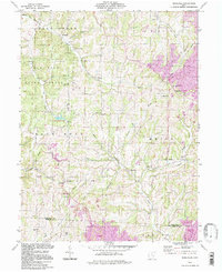
(17)- 1992 Map of Gratiot, 1995 Print
 1992 Gratiot1995 Print · USGSThe Licking and Muskingum county line comes alive in the early nineties, showing a landscape shaped by both the historic National Road and modern industry. Researchers can trace rural genealogy at Mt Olive Ch Cem or locate the old Mt Sterling post office near active Strip Mines.
 - 1992 Map of Fultonham, 1995 Print
 1992 Fultonham1995 Print · USGSThe hill country of Perry and Muskingum Counties comes into focus in the early nineties, revealing a landscape defined by mining and forest. Genealogists can trace family names at Uniontown Cem, Madison Sch, and Wesley Chapel.
 - 1992 Map of Zanesville West, 1995 Print
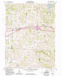
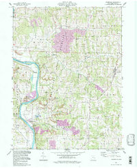
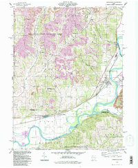
 1992 Zanesville West1995 Print · USGSZanesville and the Muskingum River valley are shown in the early nineties, documenting the city's growth and its industrial periphery. Researchers can locate numerous family landmarks like Wesley Union Cem, Williams Cem, and schools such as Norval Park Sch.
 - 1993 Map of Bloomfield
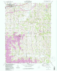
 1993 Bloomfield1993 Print · USGSGuernsey County's rural landscape is captured here in the early nineties, showing a region defined by winding creek valleys and hilltop settlements. Researchers can trace family history through sites like Indian Camp, Northfield Cem, and the Mt Harmon Ch near the banks of Wills Creek Lake.
 - 1993 Map of Plainfield
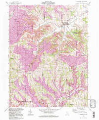
 1993 Plainfield1993 Print · USGSThe eastern Ohio borderlands of Coshocton and Guernsey counties appear here in the early nineties, centered on the complex shoreline of Wills Creek Lake. Researchers can locate several burial grounds like Schweitzer Cem and trace the paths of the Old RR Gr through Birds Run.
 - 1994 Map of Plainfield, 1998 Print
 1994 Plainfield1998 Print · USGSEastern Ohio's river valleys and coal-rich hills are shown here in the 1990s as Wills Creek winds through the meeting point of three counties. Researchers can trace rural lineages through numerous local sites including Linton Mills, Plainfield Cem, and Birds Run.
 - 1994 Map of New Concord, 1998 Print
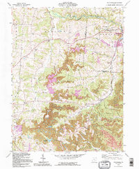
 1994 New Concord1998 Print · USGSMuskingum and Guernsey counties are captured here in the mid-1990s, showcasing the intersection of academic life and heavy industry. Researchers can trace the Baltimore and Ohio rail corridor or locate landmarks like Muskingum College and Rix Mills.
 - 1994 Map of Cumberland, 1998 Print
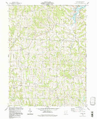
 1994 Cumberland1998 Print · USGSSoutheastern Ohio's hill country is captured here during the 1990s as it transitioned through large-scale land reclamation. Genealogists and local historians can trace family locations near Young Hickory, Cumberland, and rural landmarks like Mt Zion Cem or the Township Sch.
 - 1994 Map of Adamsville, 1998 Print
 1994 Adamsville1998 Print · USGSEastern Muskingum County remains a landscape of river valleys and rural crossroads in the 1990s, where traditional farming meets modern resource extraction. Researchers can locate dozens of historic sites, from Bethesda Ch and Stoner Cem to the Zanesville State Nursery.
 - 1994 Map of Norwich, 1998 Print
 1994 Norwich1998 Print · USGSMuskingum County at the end of the century shows a landscape where historic township lines and modern highways meet. Genealogists can locate family sites near Chandlersville, Smith Mill, and the Salt Creek Ch Cem.
 - 1994 Map of Wills Creek, 1998 Print
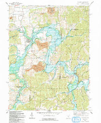
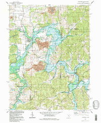
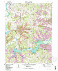 1994 Wills Creek1998 Print · USGSThe Wills Creek valley was a hub of mining and water management in the late twentieth century. Genealogists and local researchers can trace the roads to Marquand Mills, Our Lady of Lourdes Ch, and the Wills Creek Dam.
 - 1994 Map of Otsego, 1998 Print
 1994 Otsego1998 Print · USGSMuskingum County rural life remained centered on small crossroads and watercourses in the mid-1990s. Genealogists and historians can trace family locations near the Townhall, Drummond Knob, and country congregations like New Hope Ch.
 - 1994 Map of Ruraldale, 1998 Print
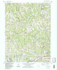
 1994 Ruraldale1998 Print · USGSSoutheast Ohio's ridge-and-hollow country is captured here in the 1990s, where public forest lands meet an evolving industrial landscape. Researchers can locate remote family sites like Bethlehem Cem, the community of Museville, and the Blue Rock Lookout Tower.
 - 1994 Map of Philo, 1998 Print
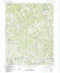
 1994 Philo1998 Print · USGSThe Muskingum River valley in the late twentieth century remains a landscape of industrial history and rural isolation. Genealogists and historians can locate family landmarks like Irish Ridge Cem or trace the legacy of extractive industry at Cannelville and the strip mines.
 - 1994 Map of Conesville, 1998 Print
 1994 Conesville1998 Print · USGSThe Muskingum River valley during the late twentieth century reveals a landscape shaped by coal extraction and river commerce. Researchers can locate numerous family burial grounds like Warner Ch Cem and rural settlements such as New Moscow or Adams Mills.
 - 1994 Map of Bloomfield, 1998 Print
 1994 Bloomfield1998 Print · USGSGuernsey and Muskingum counties are shown here in the 1990s, captured just before the turn of the century. You can trace family roots at Northfield Cem, locate the Indian Camp Covered Bridge, or find old schools like Pike Sch.
 - 1994 Map of Zanesville East, 1998 Print
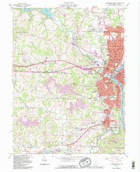
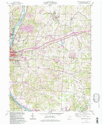 1994 Zanesville East1998 Print · USGSZanesville and the Muskingum River valley appear here in the mid-1990s as a landscape of industry and community. Genealogists can trace family names at Greenwood Cemetery or Bowers Cem and locate vanished rural schoolhouses like Monroe Sch.
End of results
Showing maps 1-17 of 17
Top cities of Muskingum County
- Zanesville historical maps
- Hopewell historical maps
- New Concord historical maps
- South Zanesville historical maps
- Dresden historical maps
- Brush Creek historical maps
See more
Frequently asked questions
- What are the different types of historical maps available for Muskingum County?
- What is the oldest map of Muskingum County?
- Where can I purchase historical maps of Muskingum County for my home or office?
- Where can I download high-res historical maps of Muskingum County?
- Are there historical topographic maps available for Muskingum County?
- Is there historical aerial imagery available for Muskingum County?
- Where are historical maps of Muskingum County sourced from?