1900-1909 Maps of Ottawa County, Ohio
Explore 11 historic maps of Ottawa County from 1900-1909. These maps offer a rare glimpse into what life looked like during the 1900s — showing old roads, neighborhoods, homes, and landmarks that have changed or disappeared over time.
Whether you're researching your family's past, planning a metal detecting trip, or studying how Ottawa County's landscape evolved across the 1900s, these high-resolution maps are a powerful tool for exploring the history of this region.
- Focus on a specific era: All maps on this page are from the 1900s, giving you a focused view of this time period.
- See what’s changed: Compare century-old streets, trails, and buildings to today's modern landscape using overlays and satellite layers.
- Research with precision: Use these maps for genealogy, historical research, land use analysis, or educational projects.
- View, download, or print: Maps are fully viewable online in high resolution, and can be downloaded or printed for your own records.
Start exploring Ottawa County's history through authentic maps from the 1900s. This is your window into the past.
Ottawa County, OH maps
(11)- 1900 Map of Maumee Bay, 1921 Print
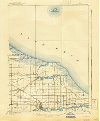
 1900 Maumee Bay1921 Print · USGSNorthwest Ohio and the Lake Erie shoreline are shown here just as the regions rail and energy sectors were maturing. Genealogists and historians can locate vanished post offices at Shepardsville Bono P. O. and trace early industrial sites like the Oil Wells and Coke Ovens near Curtice.2 unique versions available
 - 1900 Map of Oak Harbor, 1943 Print
 1900 Oak Harbor1943 Print · USGSOttawa County shorelines and rail hubs are preserved here at the turn of the century, showing the region before modern development. Genealogists and historians can trace the early layouts of Oak Harbor, the military grounds at Camp Perry, and the path of the Toledo Div. railroad.2 unique versions available
 - 1901 Map of Put-In-Bay, 1958 Print
 1901 Put-In-Bay1958 Print · USGSOttawa County's shoreline and the famous Lake Erie islands are captured at the start of the twentieth century, before modern development reshaped the coast. Genealogists and historians can trace the rail lines of the Lakeside and Sandusky Line and locate early settlements like Gypsum and St. George.
 - 1901 Map of Bellevue, 1958 Print
 1901 Bellevue1958 Print · USGSAcross the marshy lowlands and limestone springs of Erie and Sandusky counties at the turn of the century, a massive railroad network dominates the landscape. Genealogists can trace family footprints in Clyde and Bellevue or locate vanished rail stops at Thames and Parkertown.
 - 1901 Map of Fremont, 1961 Print
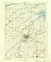
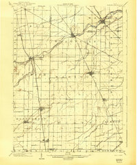
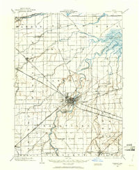 1901 Fremont1961 Print · USGSSandusky County at the dawn of the twentieth century is a bustling corridor of steam and electric rail lines. Trace the industrial footprint of Fremont and locate vanished rural junctions like Kingsway, Havens, and the Seneca Indian Reservation.
 - 1901 Map of Elmore, 1961 Print
 1901 Elmore1961 Print · USGSNorthwest Ohio at the turn of the century was a landscape of thriving rail towns and fertile township acreage. You can trace the path of the Lake Shore Electric Railway through Woodville or locate early settlements like Pemberville and Rising Sun.
 - 1903 Map of Bellevue
 1903 Bellevue1903 Print · USGSNear the dawn of the twentieth century, the junction of Erie and Sandusky counties was a bustling corridor of rail and water transport. Genealogists and historians can trace the early footprints of Bellevue and Clyde, or find specific local landmarks like the Blue Hole and the Connecticut Western Reserve Boundary Line.5 unique versions available
 - 1903 Map of Fremont, 1934 Print
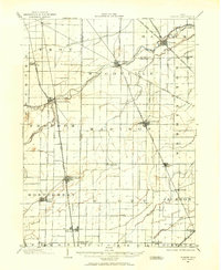
 1903 Fremont1934 Print · USGSNorthwest Ohio at the turn of the century was a bustling intersection of heavy rail and river commerce centered on the Sandusky River. Researchers can trace the early footprints of Fremont and Green Spring or locate smaller stops along the Wheeling and Lake Erie and the electric line to Ballville.2 unique versions available
 - 1903 Map of Put In Bay, 1939 Print
 1903 Put In Bay1939 Print · USGSOttawa County's shoreline and islands are captured in the early twentieth century, showing a world of maritime transit and early rail. Genealogists can trace the early layout of Port Clinton and the distinct settlements of Put in Bay, Gypsum, and Lakeside.
 - 1903 Map of Elmore, 1943 Print
 1903 Elmore1943 Print · USGSNorthwest Ohio at the turn of the century was a hive of competing rail lines and riverside market towns. Researchers can trace the early industrial footprints of Gibsonburg, Pemberville, and Elmore alongside the Ohio Central System and Wolf Creek.
 - 1904 Map of Sandusky, 1941 Print
 1904 Sandusky1941 Print · USGSThe Lake Erie shoreline at the turn of the century shows a bustling rail-and-port economy centered on Sandusky and the Huron River. Researchers can trace early infrastructure like the Electric Line and vanished landmarks such as the State Soldiers Home.3 unique versions available
End of results
Showing maps 1-11 of 11
Top cities of Ottawa County
Frequently asked questions
- What are the different types of historical maps available for Ottawa County?
- What is the oldest map of Ottawa County?
- Where can I purchase historical maps of Ottawa County for my home or office?
- Where can I download high-res historical maps of Ottawa County?
- Are there historical topographic maps available for Ottawa County?
- Is there historical aerial imagery available for Ottawa County?
- Where are historical maps of Ottawa County sourced from?