
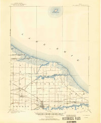
1900 Map of Oak Harbor
USGS Topo · Published 1943About this map
Oak Harbor serves as a primary hub of activity along the Portage River in this turn-of-the-century landscape. The map details a region defined by its industrial transit and shoreline development, where the Lake Shore and Michigan Southern R. R. and the Wheeling and Lake Erie R. R. intersect near settlements like Limestone and Rocky Ridge. To the east, the military grounds of Camp Perry are positioned near the mouth of Lacarpe Creek along the Lake Erie coast.
Find a feature on this map
30 named features on this map. Tap any name to fly to it.
Don’t see what you’re looking for? This feature index may not catch every label — zoom into the map to look around manually.
Map Details
Editions of this 1900 Oak Harbor Map
2 editions found
Other maps of this area

1900 · Maumee Bay
USGS Topo · 1:62,500

1901 · Put-In-Bay
USGS Topo · 1:62,500

1901 · Bellevue
USGS Topo · 1:62,500

1901 · Fremont
USGS Topo · 1:62,500

1901 · Elmore
USGS Topo · 1:62,500

1903 · Bellevue
USGS Topo · 1:62,500

1903 · Fremont
USGS Topo · 1:62,500

1903 · Put In Bay
USGS Topo · 1:62,500

1903 · Elmore
USGS Topo · 1:62,500

1912 · Monroe
USGS Topo · 1:62,500