1990s Maps of Perry County, Ohio
Explore 8 historic maps of Perry County from the 1990s. These maps offer a rare glimpse into what life looked like during the 1990s — showing old roads, neighborhoods, homes, and landmarks that have changed or disappeared over time.
Whether you're researching your family's past, planning a metal detecting trip, or studying how Perry County's landscape evolved across the 1990s, these high-resolution maps are a powerful tool for exploring the history of this region.
- Focus on a specific era: All maps on this page are from the 1990s, giving you a focused view of this time period.
- See what’s changed: Compare century-old streets, trails, and buildings to today's modern landscape using overlays and satellite layers.
- Research with precision: Use these maps for genealogy, historical research, land use analysis, or educational projects.
- View, download, or print: Maps are fully viewable online in high resolution, and can be downloaded or printed for your own records.
Start exploring Perry County's history through authentic maps from the 1990s. This is your window into the past.
Perry County, OH maps
(8)- 1992 Map of Glenford, 1995 Print
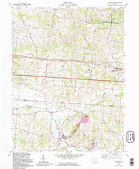 1992 Glenford1995 Print · USGSPerry and Licking counties appear here in the early nineties, showing a landscape shaped by ancient history and the oil industry. Genealogists can trace family landmarks like Ellis Chapel, Highland Cem, and the prominent Indian Mound near Claylick Creek.
 - 1992 Map of Thornville, 1995 Print
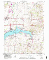 1992 Thornville1995 Print · USGSBuckeye Lake and its surrounding communities are captured here in the early nineties, showing a landscape defined by water and rural heritage. Researchers can trace historic property boundaries like the Refugee Lands line or locate family names at Hebron Cem and Thornville.
 - 1992 Map of Gratiot, 1995 Print
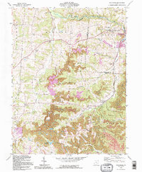
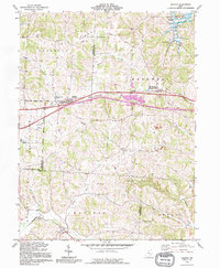 1992 Gratiot1995 Print · USGSThe Licking and Muskingum county line comes alive in the early nineties, showing a landscape shaped by both the historic National Road and modern industry. Researchers can trace rural genealogy at Mt Olive Ch Cem or locate the old Mt Sterling post office near active Strip Mines.
 - 1992 Map of New Lexington, 1995 Print
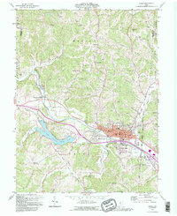
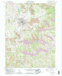 1992 New Lexington1995 Print · USGSPerry County's coal and gas country is preserved here in the late twentieth century, showing the intersection of industry and rural life. Genealogists can trace family names at Maplewood Cemetery or locate smaller settlements like Moxahala and McCuneville.
 - 1992 Map of Logan, 1995 Print
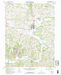
 1992 Logan1995 Print · USGSThe Hocking River valley in the early nineties shows a busy transition between the industrial hub of Logan and the recreational waters of Lake Logan. Local researchers can locate numerous historic country churches and burial grounds, including Antioch Cem, Bethany Ch, and the Marion Sch Cem.
 - 1992 Map of Fultonham, 1995 Print
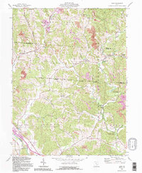
 1992 Fultonham1995 Print · USGSThe hill country of Perry and Muskingum Counties comes into focus in the early nineties, revealing a landscape defined by mining and forest. Genealogists can trace family names at Uniontown Cem, Madison Sch, and Wesley Chapel.
 - 1992 Map of Gore, 1995 Print
 1992 Gore1995 Print · USGSHocking and Perry counties appear here during the early nineties, showcasing a terrain defined by industrial rail lines and deep forest. Genealogists can trace family names at Webb Chapel Cem or locate the historic iron works at Bessie Furnace and Sand Run Junction.
 - 1992 Map of Bremen, 1995 Print
 1992 Bremen1995 Print · USGSFairfield County at the end of the twentieth century shows a landscape where old oil fields meet developing rural communities. Researchers can trace family history through dozens of landmarks like Grandview Cem, Olive Branch Ch, and the crossroads at North Berne.
End of results
Showing maps 1-8 of 8
Top cities of Perry County
- New Lexington historical maps
- Crooksville historical maps
- Somerset historical maps
- Thornville historical maps
- Junction City historical maps
- New Straitsville historical maps
See more
Frequently asked questions
- What are the different types of historical maps available for Perry County?
- What is the oldest map of Perry County?
- Where can I purchase historical maps of Perry County for my home or office?
- Where can I download high-res historical maps of Perry County?
- Are there historical topographic maps available for Perry County?
- Is there historical aerial imagery available for Perry County?
- Where are historical maps of Perry County sourced from?