Old Maps of Perry County, Ohio for Academic Research
Study the evolution of Perry County with 114 high-resolution historic maps. Whether you're teaching, researching, or modeling changes in land use, these maps provide essential visual documentation of urban, environmental, and geographic change.
- Analyze long-term change: Track patterns in development, transportation, and natural features.
- Ideal for environmental or urban studies: Support academic projects with primary historical map data.
- Use in the classroom or lab: Educators and researchers rely on these maps to bring historical context to life.
These maps are a powerful tool for teaching, research, and visualizing how Perry County has changed over the decades.
Perry County, OH maps
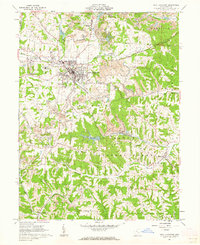
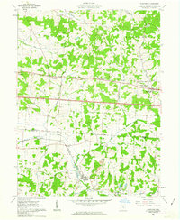
(114)- 1907 Map of Logan, 1954 Print
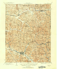 1907 Logan1954 Print · USGSSoutheast Ohio's industrial and rural landscape is captured here during the height of the local iron and rail era. Genealogists and historians can trace family roots through numerous country schools like Nickelplate School and landmarks such as Bessie Furnace or the County Infirmary.2 unique versions available
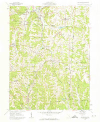
 - 1909 Map of Thornville, 1938 Print
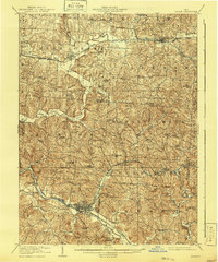
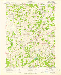
 1909 Thornville1938 Print · USGSLicking, Perry, and Fairfield counties are shown at the turn of the century as the local rail and canal-era economy remained vibrant. Researchers can trace the ancestral locations of numerous rural institutions including Porter School, Fairmount Church, and the Atherton P O at Jacksontown.2 unique versions available
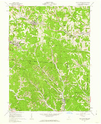
 - 1909 Map of Logan, 1941 Print
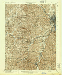
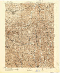
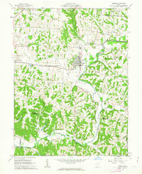
 1909 Logan1941 Print · USGSSoutheastern Ohio at the start of the twentieth century shows a landscape defined by heavy iron works and a complex rail network. Genealogists can locate family-named landmarks like Britain School or Harvey Chapel and trace the lines of the Hocking Valley R. R. through Logan.
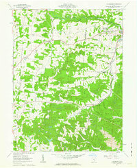
 - 1910 Map of Zanesville, 1939 Print
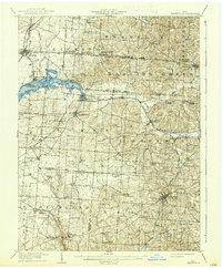
 1910 Zanesville1939 Print · USGSMuskingum and Perry counties are shown here in the early twentieth century as Zanesville emerged as a powerhouse of rail and river commerce. Researchers can trace historic transport routes like the National Road or locate local landmarks such as Moxahala Park and the Fultonham (Axline PO).2 unique versions available
 - 1911 Map of New Lexington, 1939 Print
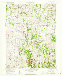
 1911 New Lexington1939 Print · USGSPerry County and its neighbors hummed with industrial activity when this survey was conducted. Local researchers can trace old rail lines and family-linked landmarks from St Aloysius Academy down to the mining hubs of Shawnee and New Straitsville.2 unique versions available
 - 1947 Map of Columbus, 1948 Print
 1947 Columbus1948 Print · USGSCentral Ohio in the late 1940s is captured in this survey, showing the post-war transition of its rail hubs and military airfield expansions. Genealogists and historians can trace the paths of the Ohio Canal, the Pennsylvania RR lines, and the Camp Sherman Military Reservation.
 - 1961 Map of Columbus
 1961 Columbus1961 Print · USGSCentral and Southern Ohio are captured here in the early sixties, as the region's industrial rail hubs and military bases reached their peak. Genealogists and historians can trace the transition from urban Columbus to rural townships along the Scioto River, locating Lockbourne USAF and old junctions like Washington Court House.
 - 1961 Map of Corning, 1962 Print
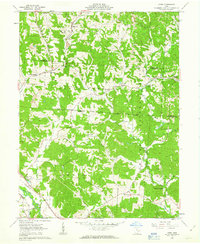
 1961 Corning1962 Print · USGSThe Hocking Valley coal country is captured here in the early sixties as the landscape shifted from mining toward new recreation. Researchers can locate old rail stops along the New York Central Railroad and trace rural roots at Mt Carmel Cem or Spencer Ridge Ch.5 unique versions available
 - 1961 Map of Rushville, 1962 Print
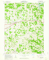
 1961 Rushville1962 Print · USGSRushville and the Fairfield County borderlands are captured here in the early 1960s as a quiet network of farmsteads and creek-side settlements. Researchers can locate many family burial sites like Woolard Cem or trace the old New York Central rail line near New Salem.4 unique versions available
 - 1961 Map of Thornville, 1962 Print
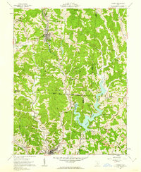
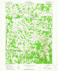
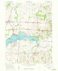 1961 Thornville1962 Print · USGSThe Buckeye Lake region in the early sixties showcases a landscape defined by lakeside recreation and historic surveying boundaries. Trace family roots at Friendship Cem or study the rail connections at Thornport and Thornville.5 unique versions available
 - 1961 Map of New Lexington, 1962 Print
 1961 New Lexington1962 Print · USGSIn the early 1960s, Perry County was a hub of rail transport and surface mining. Genealogists and historians can trace the foundations of New Lexington, locate rural burials at Bristol Cemetery, and find vanished industrial sites like the coal tipples near Dixie.4 unique versions available
 - 1961 Map of Deavertown, 1962 Print
 1961 Deavertown1962 Print · USGSSoutheastern Ohio's coal and rail landscape comes into focus during the early sixties, showing the small hamlets and resource hubs of Perry and Morgan counties. Researchers can trace the legacy of industrial settlements like San Toy and Rose Farm alongside local landmarks like Bearfield Sch and Pleasant Grove Ch.6 unique versions available
 - 1961 Map of New Straitsville, 1962 Print
 1961 New Straitsville1962 Print · USGSSoutheast Ohio's coal mining heartland is captured here in the early 1960s, showing a landscape shaped by deep hollows and active extraction. Genealogists can trace family sites at St Augustine Cem or locate former company towns like Carbon Hill and Jobs.6 unique versions available
 - 1961 Map of Fultonham, 1963 Print
 1961 Fultonham1963 Print · USGSMuskingum and Perry Counties are shown here in the early 1960s as mining and rail transport reshaped the rural landscape. Trace local heritage at Fultonham (Uniontown), find family names at Zion Ch Cem, or follow the path of the New York Central railroad.3 unique versions available
 - 1961 Map of Glenford, 1963 Print
 1961 Glenford1963 Print · USGSThe Licking and Perry County border in the early sixties was a landscape defined by historic rail junctions and ancient landmarks. Genealogists and researchers can locate family sites near Glenford, Ellis Chapel, and the Highland Cem or trace the early oil industry and Indian Mound site.3 unique versions available
 - 1961 Map of Gore, 1963 Print
 1961 Gore1963 Print · USGSHocking and Perry counties are shown here in the early sixties, where the industrial legacy of the Hocking Valley meets old land company boundaries. Genealogists and researchers can trace family sites at Webb Chapel Cem, Dawley Cem, and the old iron site at Bessie Furnace.3 unique versions available
 - 1961 Map of Crooksville, 1963 Print
 1961 Crooksville1963 Print · USGSSoutheastern Ohio at the start of the sixties is captured here as a bustling industrial landscape of rail lines and extraction sites. You can trace the development of the Pennsylvania railroad through Roseville or locate family roots near Rose Hill Cem and Ebenezer Ch.5 unique versions available
 - 1961 Map of Logan, 1963 Print
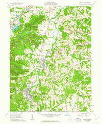
 1961 Logan1963 Print · USGSHocking County at the start of the 1960s shows a landscape defined by the winding Hocking River and the steady hum of the oil and rail industries. Researchers can locate family sites at Oak Grove Cemetery, the Marion Sch, or trace the old Chesapeake and Ohio rail corridor.4 unique versions available
 - 1961 Map of Bremen, 1963 Print
 1961 Bremen1963 Print · USGSThe rail-and-oil economy of Fairfield County is on full display in the early 1960s, centered on the village of Bremen. Trace family history through numerous rural sites like Swartz Mill, Mendonite Cem, and Olive Branch Ch scattered among the hills and creek valleys.3 unique versions available
 - 1961 Map of Somerset, 1963 Print
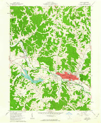
 1961 Somerset1963 Print · USGSPerry County in the early sixties reveals a landscape shaped by the Baltimore and Ohio Railroad and a mix of rural industry. Genealogists and local historians can trace family locations near New Reading, St Josephs Priory, and the historic Ream Cem.3 unique versions available
 - 1961 Map of Junction City, 1963 Print
 1961 Junction City1963 Print · USGSPerry County's industrial and rural character is on full display in the early 1960s, centered on the rail crossroads of Junction City. Genealogists can trace family names and sites like the Ohio State Penitentiary Branch, Old Zion Ch Cem, and Crossenville.3 unique versions available
 - 1962 Map of Columbus
 1962 Columbus1962 Print · USGSCentral Ohio during the early sixties reveals a transition from the industrial corridors of Columbus to the forested ridges of the south. Genealogists and historians can trace the rail networks of the Baltimore & Ohio RR and find local landmarks like Washington Court House and Camp Sherman Military Reservation.
 - 1962 Map of Gratiot, 1963 Print
 1962 Gratiot1963 Print · USGSLicking and Muskingum counties come together during the early 1960s, a landscape defined by the high ground of Flint Ridge and small crossroads towns. Researchers can locate family landmarks like the Poplar Fork Cem or trace the route of the New York Central past a historic Covered Bridge.3 unique versions available
 - 1967 Map of Columbus, 1969 Print
 1967 Columbus1969 Print · USGSCentral Ohio during the late sixties serves as a vital corridor of rail and aviation, from the industrial streets of Springfield to the hangar lines of Lockbourne Air Force Base. Genealogists and researchers can trace the growth of towns like Circleville and London or locate rural landmarks such as St Paul church and the London Correctional Institution.2 unique versions available
 - 1984 Map of Lancaster, 1985 Print
 1984 Lancaster1985 Print · USGSCentral Ohio and the Hocking Valley come into focus during the mid-eighties as suburban growth meets the wooded ridges of the southeast. Researchers can trace transportation networks through Buckeye Lake or locate landmarks like Flint Ridge State Memorial and Moxahala Park.
Showing maps 1-25 of 114
Top cities of Perry County
- New Lexington historical maps
- Crooksville historical maps
- Somerset historical maps
- Thornville historical maps
- Junction City historical maps
- New Straitsville historical maps
See more
Frequently asked questions
- What are the different types of historical maps available for Perry County?
- What is the oldest map of Perry County?
- Where can I purchase historical maps of Perry County for my home or office?
- Where can I download high-res historical maps of Perry County?
- Are there historical topographic maps available for Perry County?
- Is there historical aerial imagery available for Perry County?
- Where are historical maps of Perry County sourced from?