1910s Maps of Pickaway County, Ohio
Explore 5 historic maps of Pickaway County from the 1910s. These maps offer a rare glimpse into what life looked like during the 1910s — showing old roads, neighborhoods, homes, and landmarks that have changed or disappeared over time.
Whether you're researching your family's past, planning a metal detecting trip, or studying how Pickaway County's landscape evolved across the 1910s, these high-resolution maps are a powerful tool for exploring the history of this region.
- Focus on a specific era: All maps on this page are from the 1910s, giving you a focused view of this time period.
- See what’s changed: Compare century-old streets, trails, and buildings to today's modern landscape using overlays and satellite layers.
- Research with precision: Use these maps for genealogy, historical research, land use analysis, or educational projects.
- View, download, or print: Maps are fully viewable online in high resolution, and can be downloaded or printed for your own records.
Start exploring Pickaway County's history through authentic maps from the 1910s. This is your window into the past.
Pickaway County, OH maps
(5)- 1910 Map of Laurelville, 1962 Print
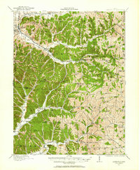 1910 Laurelville1962 Print · USGSHocking and Vinton counties come alive in the decade before the First World War, showing a landscape of ridge-top farms and valley hamlets. Genealogists can locate family landmarks like Eagle Mills, the Indian Mound, and dozens of schools including Tuling School and Union School.
 - 1911 Map of Era, 1952 Print
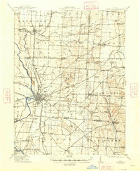
 1911 Era1952 Print · USGSPickaway County at the start of the 1900s is a landscape of established farmsteads and creekside milling. Genealogists can trace family footprints through numerous rural school sites like Tick Ridge School or Locust Grove School and find early commerce hubs like Crownover Mill and Williamsport.
 - 1912 Map of Laurelville, 1939 Print
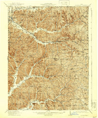 1912 Laurelville1939 Print · USGSHocking and Vinton counties at the dawn of the twentieth century show a landscape of ridge-top schools and creek-side settlements. Researchers can trace the path of the Columbus and Southern RR (Abandoned) and locate landmarks like Ash Cave and the Indian Mound.2 unique versions available
 - 1913 Map of Era, 1936 Print
 1913 Era1936 Print · USGSPickaway County agricultural life and early transport networks are preserved here in the years before the Great War. Genealogists and local historians can locate dozens of country schoolhouses like Dublin Hill School and river crossings such as Becks Ford and Gulicks Ford.
 - 1914 Map of Circleville, 1948 Print
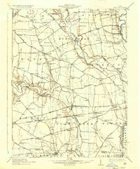
 1914 Circleville1948 Print · USGSThe Scioto River valley and Pickaway Plains are captured here during a period of thriving rail commerce and rural schoolhouse districts. Researchers can find ancestral sites from the Reber Hill Cemetery to vanished stops along the Scioto Valley and New England RR.
End of results
Showing maps 1-5 of 5
Top cities of Pickaway County
- Circleville historical maps
- Ashville historical maps
- South Bloomfield historical maps
- Williamsport historical maps
- Commercial Point historical maps
- Darbyville historical maps
Frequently asked questions
- What are the different types of historical maps available for Pickaway County?
- What is the oldest map of Pickaway County?
- Where can I purchase historical maps of Pickaway County for my home or office?
- Where can I download high-res historical maps of Pickaway County?
- Are there historical topographic maps available for Pickaway County?
- Is there historical aerial imagery available for Pickaway County?
- Where are historical maps of Pickaway County sourced from?