1990s Maps of Waverly Estates, Waverly
Explore 2 historic maps of Waverly Estates from the 1990s. These maps offer a rare glimpse into what life looked like during the 1990s — showing old roads, neighborhoods, homes, and landmarks that have changed or disappeared over time.
Whether you're researching your family's past, planning a metal detecting trip, or studying how Waverly Estates's landscape evolved across the 1990s, these high-resolution maps are a powerful tool for exploring the history of this region.
- Focus on a specific era: All maps on this page are from the 1990s, giving you a focused view of this time period.
- See what’s changed: Compare century-old streets, trails, and buildings to today's modern landscape using overlays and satellite layers.
- Research with precision: Use these maps for genealogy, historical research, land use analysis, or educational projects.
- View, download, or print: Maps are fully viewable online in high resolution, and can be downloaded or printed for your own records.
Start exploring Waverly Estates's history through authentic maps from the 1990s. This is your window into the past.
Waverly Estates, Waverly maps
(2)- 1992 Map of Waverly South, 1995 Print
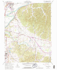 1992 Waverly South1995 Print · USGSPike County's river-bottom farms and heavy industry are captured here in the early nineties, centered on the Scioto valley. Researchers can trace family history through dozens of rural sites like Evergreen Cem, Zahns Corners, and the historic Piketon Sch.
 - 1992 Map of Waverly North, 1995 Print
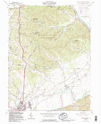 1992 Waverly North1995 Print · USGSThe Scioto River valley comes alive in this early 1990s record of the Ross and Pike County borderlands. Researchers can trace the path of the Erie Canal (Abandoned) or locate family burial grounds like Sugar Tree Cem and Corwine Cem.
End of results
Showing maps 1-2 of 2
Frequently asked questions
- What are the different types of historical maps available for Waverly Estates?
- What is the oldest map of Waverly Estates?
- Where can I purchase historical maps of Waverly Estates for my home or office?
- Where can I download high-res historical maps of Waverly Estates?
- Are there historical topographic maps available for Waverly Estates?
- Is there historical aerial imagery available for Waverly Estates?
- Where are historical maps of Waverly Estates sourced from?