Old Maps of Preble County, Ohio for Hiking & Exploration
Hike through history with 107 historic maps of Preble County. Explore old trails, ghost towns, and forgotten backroads — perfect for outdoor adventurers and local explorers.
- Rediscover forgotten places: Map out old mining camps, roads, and footpaths that no longer exist on modern maps.
- Layer with modern tools: Combine with LiDAR or satellite views to plan hikes through historical terrain.
- Made for exploration: Popular among hikers, overlanders, and local history lovers.
Use these maps to find adventure and explore the hidden past of Preble County.
Preble County, OH maps
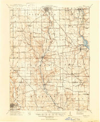
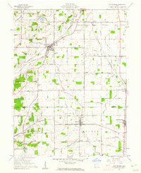
(107)- 1905 Map of Brookville, 1953 Print
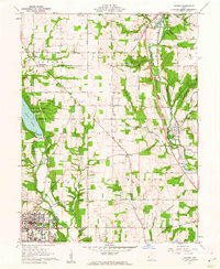
 1905 Brookville1953 Print · USGSWestern Montgomery County in the early 1900s shows a landscape of rail-connected farming towns and early river management. Trace the path of the historic National Road through Arlington or locate family sites near Shiloh Church and Harshbarger Schoolhouse.
 - 1908 Map of Miamisburg, 1948 Print
 1908 Miamisburg1948 Print · USGSThe Miami Valley at the start of the twentieth century was a hub of electric traction lines and canal history. Genealogists and historians can trace the early layouts of Miamisburg and Franklin, or locate landmarks like Browns Chapel and the National Military Home.
 - 1911 Map of Oxford, 1950 Print
 1911 Oxford1950 Print · USGSOxford and its surrounding townships thrived as centers of education and commerce in the early twentieth century. Genealogists can trace family footprints across dozens of local school districts, from Flora School to Cotton Run School, and locate rural landmarks like Halderman Mill or Maple Grove Church.
 - 1915 Map of New Paris
 1915 New Paris1915 Print · USGSThe Indiana-Ohio borderlands at the onset of the Great War reveal a landscape of thriving rail hubs and pioneer roads. Genealogists and researchers can trace the early layouts of Hollansburg, Campbellstown, and Sunbeam, or follow the path of the historic National Road.
 - 1915 Map of College Corner
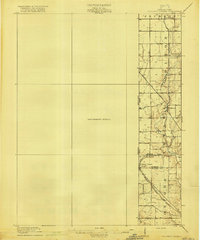
 1915 College Corner1915 Print · USGSThe Indiana-Ohio borderlands at the start of the twentieth century are defined here by rail hubs and rural townships. Trace family roots and vanished landmarks near College Corner, Concord Church, and the winding Fourmile Creek.
 - 1918 Map of College Corner
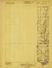
 1918 College Corner1918 Print · USGSThe Indiana-Ohio borderlands come into focus during the Great War era, showing the intersection of rail and road commerce. Genealogists and historians can trace the early layout of College Corner, the grounds of Tallawanda Springs, and rural landmarks like School No 3.4 unique versions available
 - 1918 Map of New Paris, 1922 Print
 1918 New Paris1922 Print · USGSThe Indiana-Ohio border during the First World War reveals a landscape defined by pioneering electric railways and historic transit corridors. Genealogists and historians can trace the growth of New Paris and Hollansburg, or locate small communities like Sunbeam and Cedar Springs.
 - 1953 Map of Cincinnati, 1965 Print
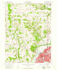
 1953 Cincinnati1965 Print · USGSThe Ohio River valley and the industrial heartland of Indiana and Ohio are captured here during the mid-century peak of rail and river commerce. Genealogists and historians can trace connections between Cincinnati and outlying military sites like Camp Atterbury and Bakalar AFB.3 unique versions available
 - 1957 Map of Cincinnati
 1957 Cincinnati1957 Print · USGSThe Ohio River valley and its surrounding highlands thrived during the mid-fifties industrial peak, centered on the bustling Cincinnati and Dayton metropolitan hubs. Researchers can trace the extensive rail networks and military sites like Wright-Patterson AFB and Camp Atterbury.
 - 1959 Map of Middletown, 1961 Print
 1959 Middletown1961 Print · USGSThe Miami Valley in the late fifties shows a region in transition between its river-and-rail origins and the modern industrial era. Genealogists can trace family names through the Elk Creek Cem, Astoria Cem, and local school locations like Madison High Sch.5 unique versions available
 - 1960 Map of New Madison, 1961 Print
 1960 New Madison1961 Print · USGSWestern Darke County was a busy intersection of rail and agriculture in the early sixties. Genealogists and local historians can trace family land via New Madison, locate the Township Sch, or find ancestors at Greenmound Cem and Otterbine Cem.3 unique versions available
 - 1960 Map of Fairhaven, 1961 Print
 1960 Fairhaven1961 Print · USGSThe Indiana-Ohio state line was a landscape of quiet agricultural hamlets and steam-era rail lines in the early sixties. Genealogists can trace the rural communities of Fairhaven and Goodwins Corner, along with the Sugar Grove Ch and several local cemeteries.2 unique versions available
 - 1960 Map of Whitewater, 1961 Print
 1960 Whitewater1961 Print · USGSThe Indiana-Ohio borderlands at the start of the sixties reveal a landscape of thriving crossroads and river-valley farms. Genealogists can trace family footprints through the Middleboro settlement, Friendship Ch, and several rural burial grounds like Bethel Cem.3 unique versions available
 - 1960 Map of New Paris, 1961 Print
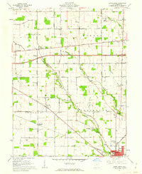
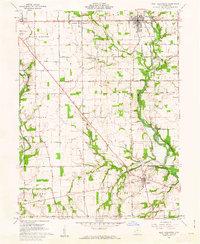
 1960 New Paris1961 Print · USGSThe Indiana-Ohio border comes alive in the early sixties as the city of Richmond expands toward New Paris. Genealogists and historians can trace family locations through Smyrna Ch, Spring Lawn Cemetery, and the many farms along the historic National Road.4 unique versions available
 - 1960 Map of College Corner, 1961 Print
 1960 College Corner1961 Print · USGSCollege Corner sits at the crossroads of Indiana and Ohio at the start of the 1960s, a landscape defined by intersecting railroads and state lines. Genealogists can trace family roots through College Corner Cemetery, Hopewell Ch, and the rural settlement of Charlottesville.4 unique versions available
 - 1960 Map of Eaton North, 1962 Print
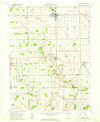
 1960 Eaton North1962 Print · USGSWestern Ohio farm country is meticulously documented in the early sixties, showing the rail and road networks connecting New Hope and EATON. Researchers can trace ancestral locations through Township Sch, Wares Chapel, and family burial sites like Stump Cem.2 unique versions available
 - 1960 Map of Farmersville, 1962 Print
 1960 Farmersville1962 Print · USGSFarmersville and western Montgomery County appear in the early 1960s as a landscape of productive farmsteads and managed river valleys. Researchers can trace rural life via the Township Sch, family-named roads like Moses Road, and the Germantown Dam.4 unique versions available
 - 1960 Map of Eaton South, 1962 Print
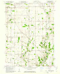
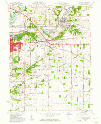
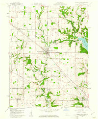
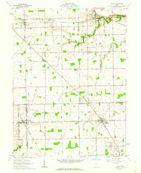
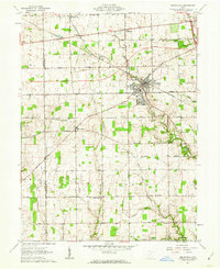
 1960 Eaton South1962 Print · USGSPreble County thrives at the dawn of the 1960s, showing the settled landscape between the county seat and the southern rail hub. Researchers can trace historic family burial sites like Gard Cem or visit landmarks like the Covered Bridge and Fort St Clair State Park.4 unique versions available
 - 1961 Map of Oxford, 1962 Print
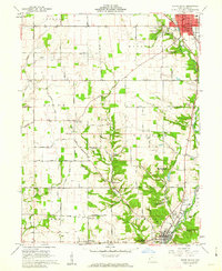
 1961 Oxford1962 Print · USGSButler and Preble counties come into focus during the early sixties, showing the expansion of Miami University alongside traditional farmsteads. Researchers can trace the Pennsylvania rail corridor or locate ancestral sites like Beechwood Cem and Morning Sun.4 unique versions available
 - 1961 Map of Laura, 1962 Print
 1961 Laura1962 Print · USGSWestern Ohio farm country and quiet crossroads villages thrive in the early sixties across this multi-county border. Genealogists can trace family names through Mote Cem and Swank Cem or locate old homesteads near Potsdam and Pittsburg.2 unique versions available
 - 1961 Map of Lewisburg, 1962 Print
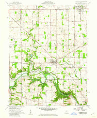
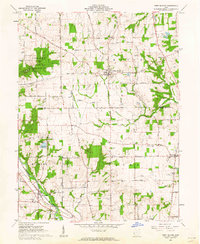
 1961 Lewisburg1962 Print · USGSPreble County in the early 1960s was a landscape of quiet rural townships and thriving creek-side villages. Genealogists and researchers can trace local families through Sugar Grove Cemetery and explore the historic corridor of the National Road through Lewisburg.2 unique versions available
 - 1961 Map of West Elkton, 1962 Print
 1961 West Elkton1962 Print · USGSSouthwestern Ohio at the start of the sixties reveals a landscape of established farmsteads and quiet creek valleys. Genealogists can locate family landmarks like Fairmound Cem, The Little Family Ch, and the old rail stop at Collinsville.2 unique versions available
 - 1961 Map of West Alexandria, 1962 Print
 1961 West Alexandria1962 Print · USGSPreble County's rural landscape is captured here in the early sixties, showing the villages and township roads before modern highway expansion. Genealogists can trace family footprints near St Johns Ch, the Covered Bridge near Gratis, or small hamlets like Ingomar and Wheatville.3 unique versions available
 - 1961 Map of Brookville, 1962 Print
 1961 Brookville1962 Print · USGSBrookville and the surrounding townships of Montgomery and Preble counties appear here in the early 1960s as the regional rail and road networks matured. Genealogists can locate family sites near Wolf Creek Ch, Pleasant Hill Cem, and the crossroads at Pyrmont.3 unique versions available
 - 1961 Map of Arcanum, 1963 Print
 1961 Arcanum1963 Print · USGSDarke and Preble Counties in the early sixties remain a patchwork of productive farmsteads and rural rail junctions. Researchers can trace old family names through locations like Twin Creek Ch, Beechgrove Cem, and the village of Arcanum.2 unique versions available
Showing maps 1-25 of 107
Top cities of Preble County
- Eaton historical maps
- Camden historical maps
- Lewisburg historical maps
- New Paris historical maps
- West Alexandria historical maps
- Gratis historical maps
See more
Frequently asked questions
- What are the different types of historical maps available for Preble County?
- What is the oldest map of Preble County?
- Where can I purchase historical maps of Preble County for my home or office?
- Where can I download high-res historical maps of Preble County?
- Are there historical topographic maps available for Preble County?
- Is there historical aerial imagery available for Preble County?
- Where are historical maps of Preble County sourced from?