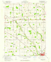
1960 Map of Eaton North
USGS Topo · Published 1962About this map
Preble County agriculture and early township boundaries define this landscape, where the Pennsylvania railroad cuts a diagonal path toward the settlement of Eaton. The rural character of the early 1960s is preserved through numerous family-named roads and localized community hubs such as New Hope and Gettysburg. A notable concentration of social history is found in the scattered rural institutions, including the Township Sch, Wares Chapel, and the County Home located just north of the city limits.
Find a feature on this map
57 named features on this map. Tap any name to fly to it.
Don’t see what you’re looking for? This feature index may not catch every label — zoom into the map to look around manually.
Map Details
Editions of this 1960 Eaton North Map
2 editions found
Other maps of this area

1911 · Oxford
USGS Topo · 1:62,500

1915 · New Paris
USGS Topo · 1:48,000

1915 · College Corner
USGS Topo · 1:48,000

1918 · College Corner
USGS Topo · 1:62,500

1918 · New Paris
USGS Topo · 1:62,500

1953 · Cincinnati
USGS Topo · 1:250,000

1957 · Cincinnati
USGS Topo · 1:250,000

1960 · New Madison
USGS Topo · 1:24,000

1960 · Fairhaven
USGS Topo · 1:24,000
1960 · Whitewater
USGS Topo · 1:24,000