1960s Maps of Verona, Ohio
Explore 2 historic maps of Verona from the 1960s. These maps offer a rare glimpse into what life looked like during the 1960s — showing old roads, neighborhoods, homes, and landmarks that have changed or disappeared over time.
Whether you're researching your family's past, planning a metal detecting trip, or studying how Verona's landscape evolved across the 1960s, these high-resolution maps are a powerful tool for exploring the history of this region.
- Focus on a specific era: All maps on this page are from the 1960s, giving you a focused view of this time period.
- See what’s changed: Compare century-old streets, trails, and buildings to today's modern landscape using overlays and satellite layers.
- Research with precision: Use these maps for genealogy, historical research, land use analysis, or educational projects.
- View, download, or print: Maps are fully viewable online in high resolution, and can be downloaded or printed for your own records.
Start exploring Verona's history through authentic maps from the 1960s. This is your window into the past.
Verona, OH maps
(2)- 1961 Map of Laura, 1962 Print
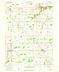 1961 Laura1962 Print · USGSWestern Ohio farm country and quiet crossroads villages thrive in the early sixties across this multi-county border. Genealogists can trace family names through Mote Cem and Swank Cem or locate old homesteads near Potsdam and Pittsburg.2 unique versions available
 - 1961 Map of Arcanum, 1963 Print
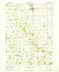 1961 Arcanum1963 Print · USGSDarke and Preble Counties in the early sixties remain a patchwork of productive farmsteads and rural rail junctions. Researchers can trace old family names through locations like Twin Creek Ch, Beechgrove Cem, and the village of Arcanum.2 unique versions available
End of results
Showing maps 1-2 of 2
Top cities near Verona
- Dayton historical maps
- Trotwood historical maps
- Piqua historical maps
- West Carrollton historical maps
- Clayton historical maps
- Greenville historical maps
See more
Frequently asked questions
- What are the different types of historical maps available for Verona?
- What is the oldest map of Verona?
- Where can I purchase historical maps of Verona for my home or office?
- Where can I download high-res historical maps of Verona?
- Are there historical topographic maps available for Verona?
- Is there historical aerial imagery available for Verona?
- Where are historical maps of Verona sourced from?