1900-1909 Maps of Glandorf Township, Ohio
Explore 4 historic maps of Glandorf Township from 1900-1909. These maps offer a rare glimpse into what life looked like during the 1900s — showing old roads, neighborhoods, homes, and landmarks that have changed or disappeared over time.
Whether you're researching your family's past, planning a metal detecting trip, or studying how Glandorf Township's landscape evolved across the 1900s, these high-resolution maps are a powerful tool for exploring the history of this region.
- Focus on a specific era: All maps on this page are from the 1900s, giving you a focused view of this time period.
- See what’s changed: Compare century-old streets, trails, and buildings to today's modern landscape using overlays and satellite layers.
- Research with precision: Use these maps for genealogy, historical research, land use analysis, or educational projects.
- View, download, or print: Maps are fully viewable online in high resolution, and can be downloaded or printed for your own records.
Start exploring Glandorf Township's history through authentic maps from the 1900s. This is your window into the past.
Glandorf Township, OH maps
(4)- 1906 Map of Columbus Grove, 1956 Print
 1906 Columbus Grove1956 Print · USGSIn the early twentieth century, Putnam and Allen Counties were centers of Ohio's rail and pike expansion. Researchers can trace historic transportation lines like the Ohio Electric Railway and locate long-standing community landmarks such as Leatherwood Church, Kalida, and Slabtown.
 - 1907 Map of Bluffton
 1907 Bluffton1907 Print · USGSNorthwestern Ohio at the height of the steam and electric rail era shows a landscape of growing college towns and productive farmland. Trace the intersection of the Ohio Northern RR and Lake Erie and Western RR, or find vanished community hubs like Lafayette Herring PO and the Hillsville School.3 unique versions available
 - 1908 Map of Columbus Grove, 1932 Print
 1908 Columbus Grove1932 Print · USGSNorthwestern Ohio at the start of the century reveals a landscape undergoing a rapid rail-driven expansion. Researchers can trace the path of the Lima and Pittsburg Electric RR and locate rural landmarks like the Leatherwood Church or the County Infirmary.
 - 1908 Map of Ottawa, 1936 Print
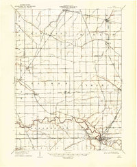 1908 Ottawa1936 Print · USGSNorthwest Ohio's agricultural landscape is seen here in the early twentieth century as a complex network of drainage ditches and competing rail lines. Genealogists can trace family roots in settlements like Glandorf, Miller City, and the rural hub of Ottawa.2 unique versions available
End of results
Showing maps 1-4 of 4
Top cities near Glandorf Township
- Ottawa historical maps
- Bluffton historical maps
- Leipsic historical maps
- Columbus Grove historical maps
- Deshler historical maps
- Pandora historical maps
See more
Top neighborhoods of Glandorf Township
Frequently asked questions
- What are the different types of historical maps available for Glandorf Township?
- What is the oldest map of Glandorf Township?
- Where can I purchase historical maps of Glandorf Township for my home or office?
- Where can I download high-res historical maps of Glandorf Township?
- Are there historical topographic maps available for Glandorf Township?
- Is there historical aerial imagery available for Glandorf Township?
- Where are historical maps of Glandorf Township sourced from?