1960s Maps of Glandorf Township, Ohio
Explore 7 historic maps of Glandorf Township from the 1960s. These maps offer a rare glimpse into what life looked like during the 1960s — showing old roads, neighborhoods, homes, and landmarks that have changed or disappeared over time.
Whether you're researching your family's past, planning a metal detecting trip, or studying how Glandorf Township's landscape evolved across the 1960s, these high-resolution maps are a powerful tool for exploring the history of this region.
- Focus on a specific era: All maps on this page are from the 1960s, giving you a focused view of this time period.
- See what’s changed: Compare century-old streets, trails, and buildings to today's modern landscape using overlays and satellite layers.
- Research with precision: Use these maps for genealogy, historical research, land use analysis, or educational projects.
- View, download, or print: Maps are fully viewable online in high resolution, and can be downloaded or printed for your own records.
Start exploring Glandorf Township's history through authentic maps from the 1960s. This is your window into the past.
Glandorf Township, OH maps
(7)- 1960 Map of Columbus Grove, 1961 Print
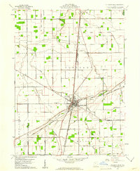 1960 Columbus Grove1961 Print · USGSColumbus Grove in the early sixties sits at a busy tri-rail junction where the landscape is still marked by the Old Indian Treaty Boundary. Genealogists can trace family lands along Trumbo Road and locate several burial sites like Bogart Cem and Truro Cem.2 unique versions available
 - 1960 Map of Bluffton, 1961 Print
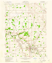
 1960 Bluffton1961 Print · USGSAgricultural life in Allen and Putnam counties reached a mid-century peak when rail lines and country roads still defined the local economy. Genealogists and historians can trace family-named landmarks like Hilty Cem and institutional hubs such as Bluffton College.4 unique versions available
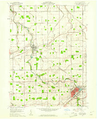
 - 1960 Map of Ottawa, 1961 Print
 1960 Ottawa1961 Print · USGSOttawa and Glandorf appear at a mid-century crossroads in this Putnam County survey, where modern developments meet historical land boundaries. Genealogists can locate family sites at SS Peter and Paul Cem or Crow Cem, while rail enthusiasts can trace the Baltimore and Ohio line.3 unique versions available
 - 1960 Map of Leipsic, 1961 Print
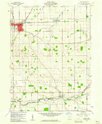 1960 Leipsic1961 Print · USGSPutnam County's rail-and-river landscape is clearly defined in the early sixties at the junction of several major freight lines. Genealogists and local historians can locate early family landmarks such as Cholera Cem, Maidlow Cem, and the County Home.2 unique versions available
 - 1961 Map of Toledo
 1961 Toledo1961 Print · USGSThe western basin of Lake Erie and the industrial heart of Northern Ohio are captured here during the post-war era. Researchers can trace historical rail lines like the New York Central or locate landmarks like the Erie Ordnance Depot and Pelee Island.
 - 1962 Map of Marion
 1962 Marion1962 Print · USGSCentral Ohio during the post-war era showcases a dense network of railroad towns and emerging interstate highways. Genealogists can trace family roots in smaller settlements like Houcktown and Marseilles or locate landmarks near Indian Lake.
 - 1966 Map of Marion, 1968 Print
 1966 Marion1968 Print · USGSCentral Ohio in the mid-sixties is captured during a period of rapid highway expansion and industrial connectivity. Genealogists and historians can trace rail-and-river networks through towns like Marion, Urbana, and Mount Vernon, or locate landmarks such as Malabar Farm and Black Hand Rock.3 unique versions available
End of results
Showing maps 1-7 of 7
Top cities near Glandorf Township
- Ottawa historical maps
- Bluffton historical maps
- Leipsic historical maps
- Columbus Grove historical maps
- Deshler historical maps
- Pandora historical maps
See more
Top neighborhoods of Glandorf Township
Frequently asked questions
- What are the different types of historical maps available for Glandorf Township?
- What is the oldest map of Glandorf Township?
- Where can I purchase historical maps of Glandorf Township for my home or office?
- Where can I download high-res historical maps of Glandorf Township?
- Are there historical topographic maps available for Glandorf Township?
- Is there historical aerial imagery available for Glandorf Township?
- Where are historical maps of Glandorf Township sourced from?