1960s Maps of Union Township, Ohio
Explore 4 historic maps of Union Township from the 1960s. These maps offer a rare glimpse into what life looked like during the 1960s — showing old roads, neighborhoods, homes, and landmarks that have changed or disappeared over time.
Whether you're researching your family's past, planning a metal detecting trip, or studying how Union Township's landscape evolved across the 1960s, these high-resolution maps are a powerful tool for exploring the history of this region.
- Focus on a specific era: All maps on this page are from the 1960s, giving you a focused view of this time period.
- See what’s changed: Compare century-old streets, trails, and buildings to today's modern landscape using overlays and satellite layers.
- Research with precision: Use these maps for genealogy, historical research, land use analysis, or educational projects.
- View, download, or print: Maps are fully viewable online in high resolution, and can be downloaded or printed for your own records.
Start exploring Union Township's history through authentic maps from the 1960s. This is your window into the past.
Union Township, OH maps
(4)- 1960 Map of Columbus Grove, 1961 Print
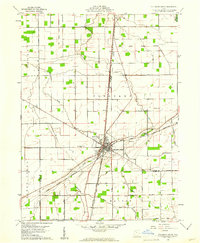 1960 Columbus Grove1961 Print · USGSColumbus Grove in the early sixties sits at a busy tri-rail junction where the landscape is still marked by the Old Indian Treaty Boundary. Genealogists can trace family lands along Trumbo Road and locate several burial sites like Bogart Cem and Truro Cem.2 unique versions available
 - 1960 Map of Ottawa, 1961 Print
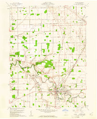 1960 Ottawa1961 Print · USGSOttawa and Glandorf appear at a mid-century crossroads in this Putnam County survey, where modern developments meet historical land boundaries. Genealogists can locate family sites at SS Peter and Paul Cem or Crow Cem, while rail enthusiasts can trace the Baltimore and Ohio line.3 unique versions available
 - 1960 Map of Miller City, 1961 Print
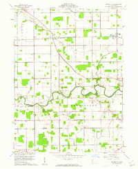 1960 Miller City1961 Print · USGSMiller City and the surrounding Putnam County townships are captured here in the early sixties, showing a landscape of precise section lines and river meanders. Researchers can locate vanished landmarks and family sites like Kieferville, Varner Cem, and the Forest Grove Ch.2 unique versions available
 - 1960 Map of Kalida, 1961 Print
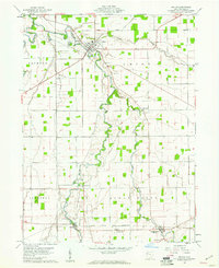 1960 Kalida1961 Print · USGSPutnam County's agricultural heartland is captured here at the start of the 1960s, centered on the confluence of the Ottawa River and Plum Creek. Genealogists can trace family footprints across several rural burial grounds like Hughes Cem and Reynolds Cem or along the southern Akron Canton and Youngstown rail line.2 unique versions available
End of results
Showing maps 1-4 of 4
Top cities near Union Township
- Lima historical maps
- Delphos historical maps
- Ottawa historical maps
- Leipsic historical maps
- Columbus Grove historical maps
- Elida historical maps
See more
Top neighborhoods of Union Township
Frequently asked questions
- What are the different types of historical maps available for Union Township?
- What is the oldest map of Union Township?
- Where can I purchase historical maps of Union Township for my home or office?
- Where can I download high-res historical maps of Union Township?
- Are there historical topographic maps available for Union Township?
- Is there historical aerial imagery available for Union Township?
- Where are historical maps of Union Township sourced from?