1930s Maps of Sandusky County, Ohio
Explore 4 historic maps of Sandusky County from the 1930s. These maps offer a rare glimpse into what life looked like during the 1930s — showing old roads, neighborhoods, homes, and landmarks that have changed or disappeared over time.
Whether you're researching your family's past, planning a metal detecting trip, or studying how Sandusky County's landscape evolved across the 1930s, these high-resolution maps are a powerful tool for exploring the history of this region.
- Focus on a specific era: All maps on this page are from the 1930s, giving you a focused view of this time period.
- See what’s changed: Compare century-old streets, trails, and buildings to today's modern landscape using overlays and satellite layers.
- Research with precision: Use these maps for genealogy, historical research, land use analysis, or educational projects.
- View, download, or print: Maps are fully viewable online in high resolution, and can be downloaded or printed for your own records.
Start exploring Sandusky County's history through authentic maps from the 1930s. This is your window into the past.
Sandusky County, OH maps
(4)- 1935 Map of Walbridge
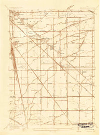 1935 Walbridge1935 Print · USGSThe rail-and-road corridors of Northwest Ohio come alive in this mid-1930s survey of the Walbridge and Millbury area. Genealogists and researchers can pinpoint family landmarks like Hayes Place, the Black Swamp Ch, and early aviation at the Toledo Landing Field.
 - 1935 Map of Genoa
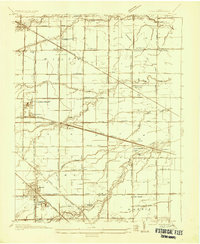 1935 Genoa1935 Print · USGSOttawa and Lucas counties come alive in the mid-1930s, revealing a landscape of limestone quarries and rural crossroads. Genealogists and historians can locate family landmarks such as the Lutheran Cemetery, tracing the industrial footprint of the U S Gypsum Company and the New York Central line.
 - 1938 Map of Walbridge
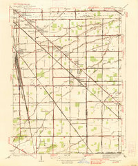 1938 Walbridge1938 Print · USGSNorthwest Ohio at the height of its rail-and-road expansion shows a landscape defined by industrial hubs and developing neighborhoods. Genealogists and historians can trace family locations near Walbridge Yard, Millbury, and rural landmarks like the Allen Cem.2 unique versions available
 - 1938 Map of Genoa
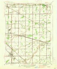 1938 Genoa1938 Print · USGSGenoa and its surrounding townships are shown in detail during the late thirties, as the region's rail and road networks were fully established. Genealogists can locate family landmarks like Williston Cem, Thorp Sch, and the quiet crossroads of Grodis Corner.2 unique versions available
End of results
Showing maps 1-4 of 4
Top cities of Sandusky County
- Fremont historical maps
- Green Creek historical maps
- Ballville historical maps
- Clyde historical maps
- York historical maps
- Gibsonburg historical maps
See more
Frequently asked questions
- What are the different types of historical maps available for Sandusky County?
- What is the oldest map of Sandusky County?
- Where can I purchase historical maps of Sandusky County for my home or office?
- Where can I download high-res historical maps of Sandusky County?
- Are there historical topographic maps available for Sandusky County?
- Is there historical aerial imagery available for Sandusky County?
- Where are historical maps of Sandusky County sourced from?