1960s Maps of Sandusky County, Ohio
Explore 15 historic maps of Sandusky County from the 1960s. These maps offer a rare glimpse into what life looked like during the 1960s — showing old roads, neighborhoods, homes, and landmarks that have changed or disappeared over time.
Whether you're researching your family's past, planning a metal detecting trip, or studying how Sandusky County's landscape evolved across the 1960s, these high-resolution maps are a powerful tool for exploring the history of this region.
- Focus on a specific era: All maps on this page are from the 1960s, giving you a focused view of this time period.
- See what’s changed: Compare century-old streets, trails, and buildings to today's modern landscape using overlays and satellite layers.
- Research with precision: Use these maps for genealogy, historical research, land use analysis, or educational projects.
- View, download, or print: Maps are fully viewable online in high resolution, and can be downloaded or printed for your own records.
Start exploring Sandusky County's history through authentic maps from the 1960s. This is your window into the past.
Sandusky County, OH maps
(15)- 1961 Map of Toledo
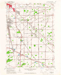
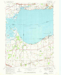
 1961 Toledo1961 Print · USGSThe western basin of Lake Erie and the industrial heart of Northern Ohio are captured here during the post-war era. Researchers can trace historical rail lines like the New York Central or locate landmarks like the Erie Ordnance Depot and Pelee Island.
 - 1965 Map of Walbridge, 1966 Print
 1965 Walbridge1966 Print · USGSSoutheast of Toledo in the mid-sixties, this region reveals a massive intersection of midwestern rail lines and the maturing interstate system. Researchers can trace the layout of Walbridge, locate Lake Cem, and see the early footprint of the Toledo Airport.3 unique versions available
 - 1966 Map of Genoa, 1968 Print
 1966 Genoa1968 Print · USGSThe rail and quarry landscapes of Ottawa County are meticulously documented during the mid-sixties. Genealogists and historians can trace family roots through Genoa, locate the Williston Cem, or study the industrial footprint of Mine Dumps at Clay Center.2 unique versions available
 - 1969 Map of Wightmans Grove, 1971 Print
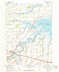 1969 Wightmans Grove1971 Print · USGSThe Sandusky River delta and the marshes of Ottawa and Sandusky counties are captured here in the late sixties. Trace family history and rural change through sites like Riley Center, Brier Hill Cem, and the riverfront at Wightmans Grove.2 unique versions available
 - 1969 Map of Fremont West, 1971 Print
 1969 Fremont West1971 Print · USGSNorthwest Ohio at the end of the sixties shows a fascinating mix of industrial growth and frontier-era heritage. Genealogists and historians can locate numerous rural burial grounds like St Marys Cem or trace the Indian Treaty Boundary near the Mull Covered Bridge.2 unique versions available
 - 1969 Map of Vickery, 1971 Print
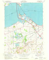
 1969 Vickery1971 Print · USGSCoastal Sandusky Bay and the interior marshlands are frozen in time just before the 1970s, showing a landscape shaped by water and industry. Genealogists and historians can trace old community anchors like Good Shepherd Ch, the Gypsum Quarry, and the small lakeside settlement at Whites Landing.
 - 1969 Map of Bellevue, 1971 Print
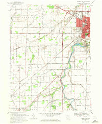
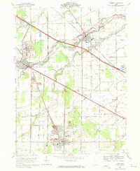
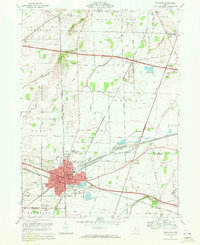 1969 Bellevue1971 Print · USGSBellevue flourished as a vital rail crossroads during the late sixties, serving as a hub where major rail lines met the rural landscape. Local historians can trace family roots through numerous sites like Bellevue Cem, Providence Ch, and several historic schoolhouses including Lyme Sch.4 unique versions available
 - 1969 Map of Bradner, 1971 Print
 1969 Bradner1971 Print · USGSNorthwest Ohio's oil-producing landscape is captured here in the late sixties, showing the industrial density of Wood and Sandusky Counties. Genealogists and researchers can pinpoint family landmarks like Bell Cem and St James Ch or trace the Penn Central rail line through Bradner and Risingsun.3 unique versions available
 - 1969 Map of Lindsey, 1971 Print
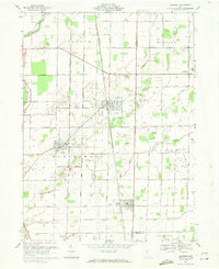
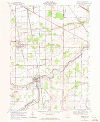
 1969 Lindsey1971 Print · USGSLindsey and the surrounding Sandusky County farmlands are captured in the late sixties as modern highways began to reshape the rural landscape. Researchers can trace family sites at Roose Cem, visit Bethel Ch, or follow the old Penn Central rail line through Hessville.
 - 1969 Map of Fremont East, 1971 Print
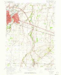 1969 Fremont East1971 Print · USGSThe Sandusky River valley in the late 1960s reveals a landscape shaped by historical boundaries and industrial growth. Researchers can trace the Old Indian Treaty Boundary, explore family lineage at Beeler Cem, or locate the St Francis of Oak Ridge Hospital.2 unique versions available
 - 1969 Map of Pemberville, 1971 Print
 1969 Pemberville1971 Print · USGSThe Portage River valley in the late sixties reveals a landscape of industrious small towns and productive rural townships. Genealogists can locate family sites near Eisenhour Cem or trace the early paths of Devils Hole Road and the Penn Central rail lines.
 - 1969 Map of Elmore, 1971 Print
 1969 Elmore1971 Print · USGSNorthwest Ohio at the close of the 1960s reveals a landscape of river-bend villages and emerging highway infrastructure. Genealogists and historians can trace family-named sites like Winkle Rd, find local schools like Welker Sch, and locate numerous Oil Wells and quarries.2 unique versions available
 - 1969 Map of Castalia, 1971 Print
 1969 Castalia1971 Print · USGSCoastal Erie County and the southern shores of Sandusky Bay come into focus in the late sixties, showcasing a landscape defined by water and industry. Genealogists and local historians can trace the foundations of Venice and Castalia, or locate the Oak Lawn Cem and Bogart Sch.2 unique versions available
 - 1969 Map of Clyde, 1971 Print
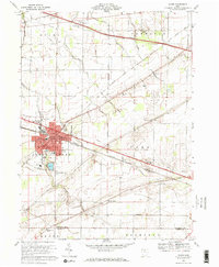 1969 Clyde1971 Print · USGSClyde and its surrounding townships are shown here in the late sixties as the regional rail and pike network reached its peak. Researchers can locate family roots at McPherson Cemetery or trace old rural hubs like Wales Corners and Colby.2 unique versions available
 - 1969 Map of Helena, 1971 Print
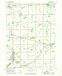
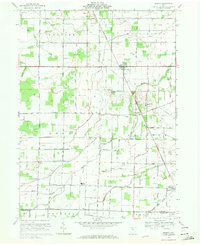 1969 Helena1971 Print · USGSSandusky County's rural landscape is captured here in the late sixties, showing a region defined by family farms, oil wells, and intersecting railroads. Genealogists and local historians can trace legacy sites like Quinshan Cemetery, the settlement of Tinney, and the Lakota High School.
End of results
Showing maps 1-15 of 15
Top cities of Sandusky County
- Fremont historical maps
- Green Creek historical maps
- Ballville historical maps
- Clyde historical maps
- York historical maps
- Gibsonburg historical maps
See more
Frequently asked questions
- What are the different types of historical maps available for Sandusky County?
- What is the oldest map of Sandusky County?
- Where can I purchase historical maps of Sandusky County for my home or office?
- Where can I download high-res historical maps of Sandusky County?
- Are there historical topographic maps available for Sandusky County?
- Is there historical aerial imagery available for Sandusky County?
- Where are historical maps of Sandusky County sourced from?