1950s Maps of Portsmouth, Ohio
Explore 3 historic maps of Portsmouth from the 1950s. These maps offer a rare glimpse into what life looked like during the 1950s — showing old roads, neighborhoods, homes, and landmarks that have changed or disappeared over time.
Whether you're researching your family's past, planning a metal detecting trip, or studying how Portsmouth's landscape evolved across the 1950s, these high-resolution maps are a powerful tool for exploring the history of this region.
- Focus on a specific era: All maps on this page are from the 1950s, giving you a focused view of this time period.
- See what’s changed: Compare century-old streets, trails, and buildings to today's modern landscape using overlays and satellite layers.
- Research with precision: Use these maps for genealogy, historical research, land use analysis, or educational projects.
- View, download, or print: Maps are fully viewable online in high resolution, and can be downloaded or printed for your own records.
Start exploring Portsmouth's history through authentic maps from the 1950s. This is your window into the past.
Portsmouth, OH maps
(3)- 1951 Map of Friendship
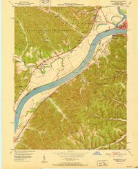 1951 Friendship1951 Print · USGSThe Ohio River valley at the turn of the 1950s shows a landscape of river-dependent industry and hill-country settlements. Researchers can trace the legacy of family homesteads through features like Morris Hill Cem, Bethel Ch, and Upper Carey Run Sch.2 unique versions available
 - 1953 Map of Portsmouth, 1955 Print
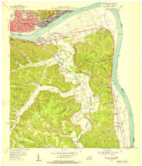 1953 Portsmouth1955 Print · USGSThe industrial hub of the Ohio River valley is captured here in the early 1950s, showing the dense rail networks and river towns of Ohio and Kentucky. Researchers can trace family sites from Portsmouth to rural hill schools like Black Oak Sch and Valley View Sch.2 unique versions available
 - 1957 Map of Huntington, 1966 Print
 1957 Huntington1966 Print · USGSThe industrial heart of the Ohio River valley is captured here in the mid-sixties, showing the growth of Huntington and Ashland. Researchers can trace the extensive rail networks of the Chesapeake and Ohio RR and locate sites like the Chief Cornstalk Hunting Ground.3 unique versions available
End of results
Showing maps 1-3 of 3
Top cities near Portsmouth
- Ironton historical maps
- Flatwoods historical maps
- Russell historical maps
- Raceland historical maps
- New Boston historical maps
- Worthington historical maps
See more
Top neighborhoods of Portsmouth
- Sciotoville historical maps
- Boneyfiddle Commercial Historic District historical maps
- North Moreland historical maps
- Sixth Street Historic District historical maps
- Second Street Historic District historical maps
Frequently asked questions
- What are the different types of historical maps available for Portsmouth?
- What is the oldest map of Portsmouth?
- Where can I purchase historical maps of Portsmouth for my home or office?
- Where can I download high-res historical maps of Portsmouth?
- Are there historical topographic maps available for Portsmouth?
- Is there historical aerial imagery available for Portsmouth?
- Where are historical maps of Portsmouth sourced from?