1910s Maps of Shelby County, Ohio
Explore 4 historic maps of Shelby County from the 1910s. These maps offer a rare glimpse into what life looked like during the 1910s — showing old roads, neighborhoods, homes, and landmarks that have changed or disappeared over time.
Whether you're researching your family's past, planning a metal detecting trip, or studying how Shelby County's landscape evolved across the 1910s, these high-resolution maps are a powerful tool for exploring the history of this region.
- Focus on a specific era: All maps on this page are from the 1910s, giving you a focused view of this time period.
- See what’s changed: Compare century-old streets, trails, and buildings to today's modern landscape using overlays and satellite layers.
- Research with precision: Use these maps for genealogy, historical research, land use analysis, or educational projects.
- View, download, or print: Maps are fully viewable online in high resolution, and can be downloaded or printed for your own records.
Start exploring Shelby County's history through authentic maps from the 1910s. This is your window into the past.
Shelby County, OH maps
(4)- 1911 Map of Loramie, 1936 Print
 1911 Loramie1936 Print · USGSWestern Ohio at the start of the twentieth century shows a landscape transitioning from the canal era to the age of electric rail. Researchers can trace the Miami and Erie Canal through Minster and New Bremen, or locate family sites near St Patricks Church and Schwaberow School.
 - 1911 Map of Covington, 1946 Print
 1911 Covington1946 Print · USGSWestern Ohio’s agricultural heartland is mapped here as a web of turnpikes and railroads connects thriving towns. Trace old family sites near Bradford, Gettysburg, and uniquely named rural landmarks like Lickskillet School or Cassels Corners.
 - 1913 Map of Sidney, 1934 Print
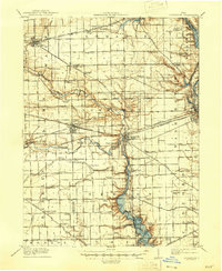
 1913 Sidney1934 Print · USGSShelby County at the height of the steam and electric rail era features a landscape defined by the Miami and Erie Canal and the historic Greenville Treaty Line. Genealogists and historians can trace dozens of rural schoolhouses, including Poplar Knob School and Walnut Grove School, alongside the early streetcar route of the Western Ohio RR.2 unique versions available
 - 1914 Map of Troy, 1931 Print
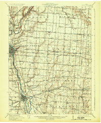 1914 Troy1931 Print · USGSMiami County at the height of the interurban era shows a landscape defined by the Miami River and competing rail lines. Genealogists can locate family landmarks like the County Infirmary or schools such as Sheepskin School and Frogpond School.2 unique versions available
End of results
Showing maps 1-4 of 4
Top cities of Shelby County
- Sidney historical maps
- Fort Loramie historical maps
- Anna historical maps
- Jackson Center historical maps
- Botkins historical maps
- Russia historical maps
See more
Frequently asked questions
- What are the different types of historical maps available for Shelby County?
- What is the oldest map of Shelby County?
- Where can I purchase historical maps of Shelby County for my home or office?
- Where can I download high-res historical maps of Shelby County?
- Are there historical topographic maps available for Shelby County?
- Is there historical aerial imagery available for Shelby County?
- Where are historical maps of Shelby County sourced from?