1960s Maps of Shelby County, Ohio
Explore 12 historic maps of Shelby County from the 1960s. These maps offer a rare glimpse into what life looked like during the 1960s — showing old roads, neighborhoods, homes, and landmarks that have changed or disappeared over time.
Whether you're researching your family's past, planning a metal detecting trip, or studying how Shelby County's landscape evolved across the 1960s, these high-resolution maps are a powerful tool for exploring the history of this region.
- Focus on a specific era: All maps on this page are from the 1960s, giving you a focused view of this time period.
- See what’s changed: Compare century-old streets, trails, and buildings to today's modern landscape using overlays and satellite layers.
- Research with precision: Use these maps for genealogy, historical research, land use analysis, or educational projects.
- View, download, or print: Maps are fully viewable online in high resolution, and can be downloaded or printed for your own records.
Start exploring Shelby County's history through authentic maps from the 1960s. This is your window into the past.
Shelby County, OH maps
(12)- 1961 Map of Piqua West, 1962 Print
 1961 Piqua West1962 Print · USGSWestern Miami County is captured here in the early sixties as the suburbs of Piqua expanded toward Newberry and Washington townships. Researchers can trace family history through sites like Forest Hill Cemetery, St Teresas Ch, and the rural Mount Jefferson crossroads.4 unique versions available
 - 1961 Map of Piqua East, 1962 Print
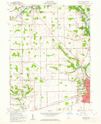
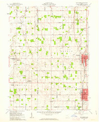
 1961 Piqua East1962 Print · USGSMiami County during the early sixties shows the industrial hub of Piqua at a crossroads of rail and river commerce. Genealogists and local historians can trace the Miami and Erie Canal path or locate family sites at Garby Cem No 1 and Kirkwood.4 unique versions available
 - 1961 Map of Fort Loramie, 1962 Print
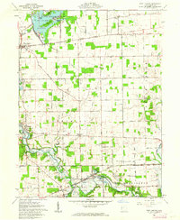 1961 Fort Loramie1962 Print · USGSShelby County's rural townships are mapped here in the early sixties, showing a landscape defined by the old Greenville Treaty Line and the historic Miami Canal. Genealogists can locate family landmarks like St Michaels New Cem, Angel Street Cem, and Hegemanns Landing.2 unique versions available
 - 1961 Map of Versailles, 1962 Print
 1961 Versailles1962 Print · USGSThe rural crossroads of Darke, Shelby, and Miami counties come into focus during the early sixties, centered on the rail hubs of Versailles and Bradford. Researchers can trace old family sites and rural landmarks like St Peters Ch, St Valberts Cem, and the Childrens Home.2 unique versions available
 - 1961 Map of Botkins, 1962 Print
 1961 Botkins1962 Print · USGSShelby and Auglaize counties are captured here in the early sixties, showing the complex intersection of early land surveys along the Greenville Treaty Line. Genealogists can trace family names across Old Loramie Valley Cem, Redman Cem, and the small community of Rumley.3 unique versions available
 - 1961 Map of Sidney, 1962 Print
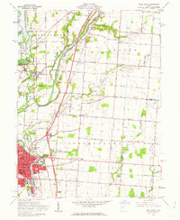
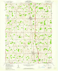
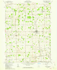
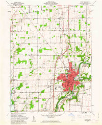 1961 Sidney1962 Print · USGSThe Miami River valley in the early 1960s shows Sidney as a thriving rail hub at the crossing of the Baltimore and Ohio and New York Central. Researchers can locate the Greenville Treaty Line, the County Fairgrounds, and old rural cemeteries like Carey Cem.3 unique versions available
 - 1961 Map of Fletcher, 1962 Print
 1961 Fletcher1962 Print · USGSIn the early 1960s, these western Ohio farm communities remained centered on their rail stops and rural churches. Genealogists can trace family footprints near Fletcher, Conover, and Plattsville, or find local burial grounds like Pioneer Cem and Sturm Cem.3 unique versions available
 - 1961 Map of New Knoxville, 1962 Print
 1961 New Knoxville1962 Print · USGSWestern Ohio farmland and the waters of Lake Loramie are frozen in time during the early sixties. Genealogists can locate family-named cemeteries like Pilger Ruhe Cem while historians trace legacy infrastructure at Lock Two and Lehmkuhl Landing.3 unique versions available
 - 1961 Map of Port Jefferson, 1962 Print
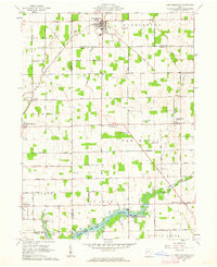
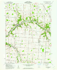 1961 Port Jefferson1962 Print · USGSShelby County farmland and the Miami River valley appear here in the early sixties, as the local economy balanced rail transport with new pipeline infrastructure. Genealogists and local historians can locate early burial sites like Old Dunkard Cem and trace the path of the old Miami Canal.3 unique versions available
 - 1961 Map of Osgood, 1963 Print
 1961 Osgood1963 Print · USGSThis western Ohio landscape at the start of the sixties reveals a countryside shaped by the historic Treaty Line and the remnants of the canal era. Genealogists can locate numerous rural burial sites like Walkup Cem and St Martins Cem near settlements like Osgood and Willowdell.3 unique versions available
 - 1961 Map of Jackson Center, 1963 Print
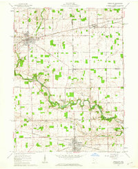
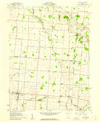
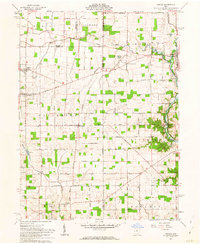
 1961 Jackson Center1963 Print · USGSShelby and Auglaize counties in the early sixties reveal a landscape defined by pioneer-era boundaries and small rail towns. Genealogists can trace family names through McCord Cem and St Jacobs Ch, or follow the path of the Detroit Toledo and Ironton railroad.3 unique versions available
 - 1961 Map of New Bremen, 1963 Print
 1961 New Bremen1963 Print · USGSAgricultural West-Central Ohio comes alive in the early sixties, showing the vital canal and rail corridors through the Auglaize and Mercer county border. Trace family roots through the Maria Stein Shrine or settlements like Egypt and Chickasaw.
End of results
Showing maps 1-12 of 12
Top cities of Shelby County
- Sidney historical maps
- Fort Loramie historical maps
- Anna historical maps
- Jackson Center historical maps
- Botkins historical maps
- Russia historical maps
See more
Frequently asked questions
- What are the different types of historical maps available for Shelby County?
- What is the oldest map of Shelby County?
- Where can I purchase historical maps of Shelby County for my home or office?
- Where can I download high-res historical maps of Shelby County?
- Are there historical topographic maps available for Shelby County?
- Is there historical aerial imagery available for Shelby County?
- Where are historical maps of Shelby County sourced from?