1960s Maps of Fort Loramie, Ohio
Explore 2 historic maps of Fort Loramie from the 1960s. These maps offer a rare glimpse into what life looked like during the 1960s — showing old roads, neighborhoods, homes, and landmarks that have changed or disappeared over time.
Whether you're researching your family's past, planning a metal detecting trip, or studying how Fort Loramie's landscape evolved across the 1960s, these high-resolution maps are a powerful tool for exploring the history of this region.
- Focus on a specific era: All maps on this page are from the 1960s, giving you a focused view of this time period.
- See what’s changed: Compare century-old streets, trails, and buildings to today's modern landscape using overlays and satellite layers.
- Research with precision: Use these maps for genealogy, historical research, land use analysis, or educational projects.
- View, download, or print: Maps are fully viewable online in high resolution, and can be downloaded or printed for your own records.
Start exploring Fort Loramie's history through authentic maps from the 1960s. This is your window into the past.
Fort Loramie, OH maps
(2)- 1961 Map of Fort Loramie, 1962 Print
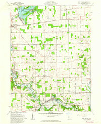 1961 Fort Loramie1962 Print · USGSShelby County's rural townships are mapped here in the early sixties, showing a landscape defined by the old Greenville Treaty Line and the historic Miami Canal. Genealogists can locate family landmarks like St Michaels New Cem, Angel Street Cem, and Hegemanns Landing.2 unique versions available
 - 1961 Map of Osgood, 1963 Print
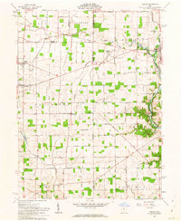 1961 Osgood1963 Print · USGSThis western Ohio landscape at the start of the sixties reveals a countryside shaped by the historic Treaty Line and the remnants of the canal era. Genealogists can locate numerous rural burial sites like Walkup Cem and St Martins Cem near settlements like Osgood and Willowdell.3 unique versions available
End of results
Showing maps 1-2 of 2
Top cities near Fort Loramie
- Piqua historical maps
- Sidney historical maps
- Greenville historical maps
- Celina historical maps
- Wapakoneta historical maps
- Saint Marys historical maps
See more
Frequently asked questions
- What are the different types of historical maps available for Fort Loramie?
- What is the oldest map of Fort Loramie?
- Where can I purchase historical maps of Fort Loramie for my home or office?
- Where can I download high-res historical maps of Fort Loramie?
- Are there historical topographic maps available for Fort Loramie?
- Is there historical aerial imagery available for Fort Loramie?
- Where are historical maps of Fort Loramie sourced from?