1900s (20th Century) Maps of Louisville, Ohio
Explore 13 historic maps of Louisville from the 1900s (20th Century). These maps offer a rare glimpse into what life looked like during the 1900s — showing old roads, neighborhoods, homes, and landmarks that have changed or disappeared over time.
Whether you're researching your family's past, planning a metal detecting trip, or studying how Louisville's landscape evolved across the 1900s, these high-resolution maps are a powerful tool for exploring the history of this region.
- Focus on a specific era: All maps on this page are from the 1900s, giving you a focused view of this time period.
- See what’s changed: Compare century-old streets, trails, and buildings to today's modern landscape using overlays and satellite layers.
- Research with precision: Use these maps for genealogy, historical research, land use analysis, or educational projects.
- View, download, or print: Maps are fully viewable online in high resolution, and can be downloaded or printed for your own records.
Start exploring Louisville's history through authentic maps from the 1900s. This is your window into the past.
Louisville, OH maps
(13)- 1901 Map of Canton, 1958 Print
 1901 Canton1958 Print · USGSStark County at the turn of the century is a landscape of growing industrial towns and busy rail corridors. Genealogists can trace family roots in New Berlin and Louisville or locate landmarks like Westlawn Cem and the Infirmary.
 - 1903 Map of Canton, 1939 Print
 1903 Canton1939 Print · USGSCanton was a flourishing rail and manufacturing center at the dawn of the century, serving as the nexus for multiple major lines. Genealogists can trace early homesteads and community centers near New Berlin, Osnaburg, and the Westlawn Cem.2 unique versions available
 - 1909 Map of Alliance
 1909 Alliance1909 Print · USGSAlliance and its surrounding industrial townships are captured in detail just after the turn of the century as the rail network reached its peak. Genealogists can trace family roots through numerous rural schools like Linden Hall School and vanished stations such as Freeburg Sta.4 unique versions available
 - 1951 Map of Canton
 1951 Canton1951 Print · USGSThe industrial heartland of Ohio and Pennsylvania reached its mid-century peak during this era of heavy rail and river transit. Genealogists and historians can trace the development of steel towns like Aliquippa and Weirton alongside the Ohio River and major lines of the Pennsylvania RR.
 - 1953 Map of Canton
 1953 Canton1953 Print · USGSThe industrial heartland of Ohio and Pennsylvania is captured at its mid-century peak in this detailed regional survey. Genealogists and historians can trace the vast rail networks of the Pennsylvania RR and find local landmarks like Nimisila Reservoir and Tappan Reservoir.
 - 1957 Map of Canton, 1971 Print
 1957 Canton1971 Print · USGSThe industrial heartland of eastern Ohio and western Pennsylvania comes alive in this mid-century survey of the Ohio River Valley. Trace the heritage of rail and river commerce through Pittsburgh, the massive steel towns along the Ohio River, and major junctions on the Pennsylvania RR.3 unique versions available
 - 1958 Map of Canton East, 1960 Print
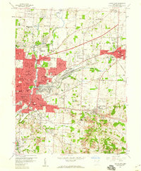 1958 Canton East1960 Print · USGSThe industrial and suburban expansion of Stark County is documented here just before the 1960s. Genealogists can trace family landmarks and neighborhood history at McKinley High Sch, St Louis Cem, and along the historic Lincoln Highway.
 - 1960 Map of Robertsville, 1961 Print
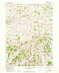 1960 Robertsville1961 Print · USGSStark County in the early 1960s was a landscape defined by its mining operations and rural rail hubs. Researchers can trace the New York Chicago and St Louis line through Robertsville or locate family sites like Beech Ch and Zwick Cem.4 unique versions available
 - 1962 Map of Canton
 1962 Canton1962 Print · USGSThe industrial heartland of Eastern Ohio and Western Pennsylvania thrives in the early sixties as steel mills and rail lines dominate the river valleys. Genealogists and historians can trace local landmarks like McKinley National Memorial, Malone College, and industrial sites such as Republic Steel Corp.2 unique versions available
 - 1967 Map of Canton East, 1970 Print
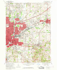 1967 Canton East1970 Print · USGSStark County's industrial and suburban landscape comes alive in the late sixties as Canton expands toward Louisville. Genealogists and historians can trace the foundations of Walsh College, locate the St Louis Cemetery, and follow the busy tracks of the Penn Central railroad.3 unique versions available
 - 1986 Map of Canton
 1986 Canton1986 Print · USGSNortheastern Ohio’s industrial corridor and rural heartland are captured here in the mid-1980s as the region's rail and highway networks reached their modern form. Researchers can trace the layout of Canton and Massillon, locate family sites near West Lawn Cemetery, or explore the grounds of Malone College and Walsh College.2 unique versions available
 - 1994 Map of Robertsville, 1998 Print
 1994 Robertsville1998 Print · USGSStark County's southern townships show a blend of intensive coal mining and rural village life during the mid-nineties. Genealogists and historians can trace family locations near Snyder Cem, Beech Ch, and the numerous strip mines that shaped the local economy.
 - 1994 Map of Canton East, 2000 Print
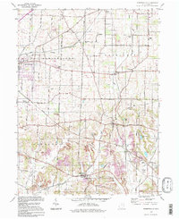
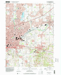 1994 Canton East2000 Print · USGSStark County's urban and industrial corridor comes into focus in the mid-nineties, showing the expansion between CANTON and LOUISVILLE. Researchers can trace family history through Warstler Cem or locate landmarks like Waco, Fairhope, and the Louisville Temple.
End of results
Showing maps 1-13 of 13
Top cities near Louisville
- Akron historical maps
- Canton historical maps
- Plain historical maps
- Massillon historical maps
- Green historical maps
- Alliance historical maps
See more
Frequently asked questions
- What are the different types of historical maps available for Louisville?
- What is the oldest map of Louisville?
- Where can I purchase historical maps of Louisville for my home or office?
- Where can I download high-res historical maps of Louisville?
- Are there historical topographic maps available for Louisville?
- Is there historical aerial imagery available for Louisville?
- Where are historical maps of Louisville sourced from?