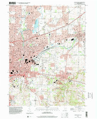
1994 Map of Canton East
USGS Topo · Published 2000About this map
The Middle Branch Nimishillen Creek and its sister branches converge within this industrial and residential landscape of eastern Stark County. The 1990s terrain reveals a dense network of suburban growth and institutional development between Canton and Louisville, anchored by local education and faith-based sites like St Thomas Aquinas Sch and Mt Zion Missionary Ch. The mapping indicates a heavy reliance on local resources, shown by the scattered Gravel Pits and a Strip Mine near East Canton, alongside a significant infrastructure of Gas Well sites that dot the townships of Nimishillen and Osnaburg. Genealogists will find particular value in the clearly marked family and community burial grounds, including the Henry Cem, St Louis Cem, and Warstler Cem, which serve as physical anchors for the area's local history.
Find a feature on this map
64 named features on this map. Tap any name to fly to it.
Don’t see what you’re looking for? This feature index may not catch every label — zoom into the map to look around manually.
Map Details
Editions of this 1994 Canton East Map
This is the sole edition of this map. No revisions or reprints were ever made.
Other maps of this area

1901 · Canton
USGS Topo · 1:62,500

1903 · Canton
USGS Topo · 1:62,500

1909 · Alliance
USGS Topo · 1:62,500

1910 · Carrollton
USGS Topo · 1:62,500

1912 · Dover
USGS Topo · 1:62,500

1912 · Carrollton
USGS Topo · 1:62,500

1944 · Dover
USGS Topo · 1:62,500

1951 · Canton
USGS Topo · 1:250,000

1951 · Bolivar
USGS Topo · 1:24,000

1953 · Canton
USGS Topo · 1:250,000