1960s Maps of Marlboro Township, Ohio
Explore 3 historic maps of Marlboro Township from the 1960s. These maps offer a rare glimpse into what life looked like during the 1960s — showing old roads, neighborhoods, homes, and landmarks that have changed or disappeared over time.
Whether you're researching your family's past, planning a metal detecting trip, or studying how Marlboro Township's landscape evolved across the 1960s, these high-resolution maps are a powerful tool for exploring the history of this region.
- Focus on a specific era: All maps on this page are from the 1960s, giving you a focused view of this time period.
- See what’s changed: Compare century-old streets, trails, and buildings to today's modern landscape using overlays and satellite layers.
- Research with precision: Use these maps for genealogy, historical research, land use analysis, or educational projects.
- View, download, or print: Maps are fully viewable online in high resolution, and can be downloaded or printed for your own records.
Start exploring Marlboro Township's history through authentic maps from the 1960s. This is your window into the past.
Marlboro Township, OH maps
(3)- 1960 Map of Limaville, 1961 Print
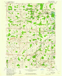 1960 Limaville1961 Print · USGSStark and Portage counties are captured here at the dawn of the sixties as small villages like Limaville and Marlboro sit amid a busy rail network. Genealogists can locate family sites like St Pauls Cem or trace the old Railroad Grade near Lexington.4 unique versions available
 - 1960 Map of Hartville, 1961 Print
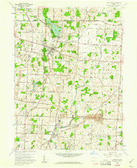 1960 Hartville1961 Print · USGSHartville and its surrounding townships are shown here in the early sixties, capturing a landscape of family farms, historic cemeteries, and local industry. Genealogists and historians can trace church sites like St Jacobs Ch and old burial grounds including Walnut Grove Sch Cem and Machamer Cem.6 unique versions available
 - 1962 Map of Canton
 1962 Canton1962 Print · USGSThe industrial heartland of Eastern Ohio and Western Pennsylvania thrives in the early sixties as steel mills and rail lines dominate the river valleys. Genealogists and historians can trace local landmarks like McKinley National Memorial, Malone College, and industrial sites such as Republic Steel Corp.2 unique versions available
End of results
Showing maps 1-3 of 3
Top cities near Marlboro Township
- Akron historical maps
- Canton historical maps
- Plain historical maps
- Cuyahoga Falls historical maps
- Stow historical maps
- Kent historical maps
See more
Top neighborhoods of Marlboro Township
Frequently asked questions
- What are the different types of historical maps available for Marlboro Township?
- What is the oldest map of Marlboro Township?
- Where can I purchase historical maps of Marlboro Township for my home or office?
- Where can I download high-res historical maps of Marlboro Township?
- Are there historical topographic maps available for Marlboro Township?
- Is there historical aerial imagery available for Marlboro Township?
- Where are historical maps of Marlboro Township sourced from?