1960s Maps of Massillon, Ohio
Explore 6 historic maps of Massillon from the 1960s. These maps offer a rare glimpse into what life looked like during the 1960s — showing old roads, neighborhoods, homes, and landmarks that have changed or disappeared over time.
Whether you're researching your family's past, planning a metal detecting trip, or studying how Massillon's landscape evolved across the 1960s, these high-resolution maps are a powerful tool for exploring the history of this region.
- Focus on a specific era: All maps on this page are from the 1960s, giving you a focused view of this time period.
- See what’s changed: Compare century-old streets, trails, and buildings to today's modern landscape using overlays and satellite layers.
- Research with precision: Use these maps for genealogy, historical research, land use analysis, or educational projects.
- View, download, or print: Maps are fully viewable online in high resolution, and can be downloaded or printed for your own records.
Start exploring Massillon's history through authentic maps from the 1960s. This is your window into the past.
Massillon, OH maps
(6)- 1961 Map of Dalton, 1962 Print
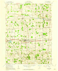 1961 Dalton1962 Print · USGSWayne and Stark counties are captured in the early sixties as a busy landscape of family farms, rail lines, and emerging energy sites. Genealogists and historians can trace family-named landmarks like Sonnenberg Cemetery, Martins Church, and the village of Kidron.3 unique versions available
 - 1961 Map of Bolivar, 1963 Print
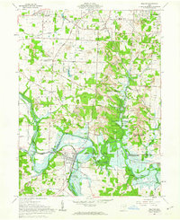 1961 Bolivar1963 Print · USGSTuscarawas and Stark County landscapes intersect in the early sixties, showing a terrain shaped by historic boundary lines and coal extraction. Researchers can trace the Ohio Canal, locate the Fort Laurens State Memorial, and find family sites like Siffert Cem.2 unique versions available
 - 1961 Map of Navarre, 1963 Print
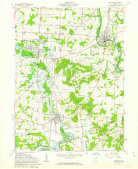 1961 Navarre1963 Print · USGSStark County in the early 1960s was a landscape defined by its industrial rail hubs and historic water routes. Genealogists and historians can trace family burial sites like Wellford Baptist Cem and Dietrick Cem or locate former airfield grounds at Ames Airport.5 unique versions available
 - 1961 Map of Massillon, 1963 Print
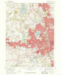
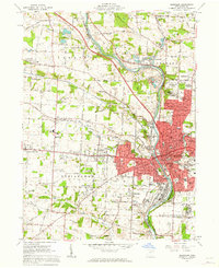 1961 Massillon1963 Print · USGSMassillon and its surrounding Stark County townships are shown in the early sixties as industrial growth meets the quiet of the Ohio countryside. Genealogists and researchers can trace family roots at Rose Hill Memorial Park, the Old Quaker Cem, or the Massillon State Hospital grounds.4 unique versions available
 - 1962 Map of Canton
 1962 Canton1962 Print · USGSThe industrial heartland of Eastern Ohio and Western Pennsylvania thrives in the early sixties as steel mills and rail lines dominate the river valleys. Genealogists and historians can trace local landmarks like McKinley National Memorial, Malone College, and industrial sites such as Republic Steel Corp.2 unique versions available
 - 1967 Map of Canton West, 1969 Print
 1967 Canton West1969 Print · USGSStark County in the late sixties shows the dense urban corridor connecting Canton and Massillon. Genealogists can trace family landmarks like Calvary Cemetery and Brunnerdale Seminary, or locate the Nat Pro Football Hall of Fame.3 unique versions available
End of results
Showing maps 1-6 of 6
Top cities near Massillon
- Akron historical maps
- Canton historical maps
- Green historical maps
- Barberton historical maps
- Wadsworth historical maps
- North Canton historical maps
See more
Top neighborhoods of Massillon
- Lawndale historical maps
- Mayflower Village historical maps
- Walnut Hills historical maps
- West Brookfield historical maps
- West Park historical maps
- Westarado historical maps
See more
Frequently asked questions
- What are the different types of historical maps available for Massillon?
- What is the oldest map of Massillon?
- Where can I purchase historical maps of Massillon for my home or office?
- Where can I download high-res historical maps of Massillon?
- Are there historical topographic maps available for Massillon?
- Is there historical aerial imagery available for Massillon?
- Where are historical maps of Massillon sourced from?