2020s Maps of Lordstown, Ohio
Explore 2 historic maps of Lordstown from the 2020s. These maps offer a rare glimpse into what life looked like during the 2020s — showing old roads, neighborhoods, homes, and landmarks that have changed or disappeared over time.
Whether you're researching your family's past, planning a metal detecting trip, or studying how Lordstown's landscape evolved across the 2020s, these high-resolution maps are a powerful tool for exploring the history of this region.
- Focus on a specific era: All maps on this page are from the 2020s, giving you a focused view of this time period.
- See what’s changed: Compare century-old streets, trails, and buildings to today's modern landscape using overlays and satellite layers.
- Research with precision: Use these maps for genealogy, historical research, land use analysis, or educational projects.
- View, download, or print: Maps are fully viewable online in high resolution, and can be downloaded or printed for your own records.
Start exploring Lordstown's history through authentic maps from the 2020s. This is your window into the past.
Lordstown, OH maps
(2)- 2023 Map of Warren, 2023 Print
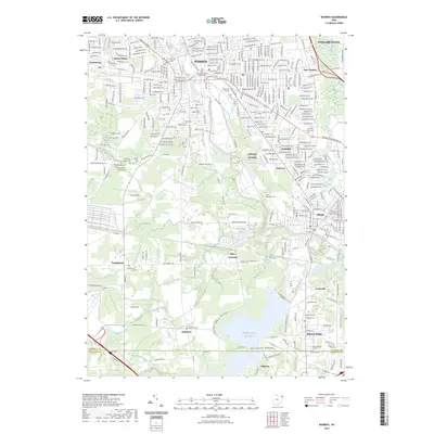 2023 Warren2023 Print · USGSThe Mahoning Valley in the early 2020s shows a landscape of deep-rooted industry and evolving suburban centers. Researchers can trace family history through sites like the Trumbull County Courthouse, Leavittsburg Cem, and Soaptown Cem.
 - 2023 Map of Newton Falls, 2023 Print
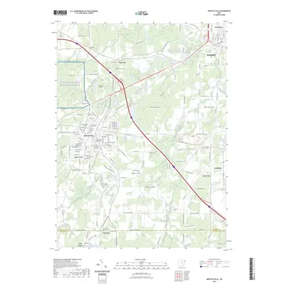 2023 Newton Falls2023 Print · USGSNewton Falls and the Mahoning River valley appear in high detail during the early 2020s. Genealogists can trace family names at West Newton Falls Cem, Braceville Center Cem, and Duck Creek Cem.
End of results
Showing maps 1-2 of 2
Top cities near Lordstown
- Youngstown historical maps
- Boardman historical maps
- Warren historical maps
- Austintown historical maps
- Weathersfield Township historical maps
- Howland Township historical maps
See more
Top neighborhoods of Lordstown
Frequently asked questions
- What are the different types of historical maps available for Lordstown?
- What is the oldest map of Lordstown?
- Where can I purchase historical maps of Lordstown for my home or office?
- Where can I download high-res historical maps of Lordstown?
- Are there historical topographic maps available for Lordstown?
- Is there historical aerial imagery available for Lordstown?
- Where are historical maps of Lordstown sourced from?