1990s Maps of Lordstown, Ohio
Explore 2 historic maps of Lordstown from the 1990s. These maps offer a rare glimpse into what life looked like during the 1990s — showing old roads, neighborhoods, homes, and landmarks that have changed or disappeared over time.
Whether you're researching your family's past, planning a metal detecting trip, or studying how Lordstown's landscape evolved across the 1990s, these high-resolution maps are a powerful tool for exploring the history of this region.
- Focus on a specific era: All maps on this page are from the 1990s, giving you a focused view of this time period.
- See what’s changed: Compare century-old streets, trails, and buildings to today's modern landscape using overlays and satellite layers.
- Research with precision: Use these maps for genealogy, historical research, land use analysis, or educational projects.
- View, download, or print: Maps are fully viewable online in high resolution, and can be downloaded or printed for your own records.
Start exploring Lordstown's history through authentic maps from the 1990s. This is your window into the past.
Lordstown, OH maps
(2)- 1994 Map of Warren, 1997 Print
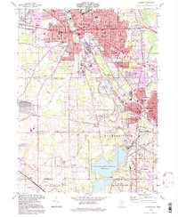 1994 Warren1997 Print · USGSThe Mahoning Valley's industrial and residential landscape is captured here in the mid-1990s, centered on the urban cores of WARREN and NILES. Trace family roots and local history through numerous sites like Harding High School, Oakwood Cemetery, and the Niles and New Lisbon Railroad.
 - 1994 Map of Newton Falls, 1997 Print
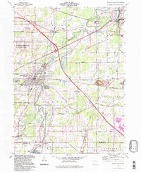 1994 Newton Falls1997 Print · USGSNewton Falls and the Mahoning River valley appear here in the late twentieth century, showing a mix of industrial corridors and small settlements. Trace the rail lines of the Conrail or locate local landmarks like Phalanx Station, Pricetown, and the St Michaels Cem.
End of results
Showing maps 1-2 of 2
Top cities near Lordstown
- Youngstown historical maps
- Boardman historical maps
- Warren historical maps
- Austintown historical maps
- Weathersfield Township historical maps
- Howland Township historical maps
See more
Top neighborhoods of Lordstown
Frequently asked questions
- What are the different types of historical maps available for Lordstown?
- What is the oldest map of Lordstown?
- Where can I purchase historical maps of Lordstown for my home or office?
- Where can I download high-res historical maps of Lordstown?
- Are there historical topographic maps available for Lordstown?
- Is there historical aerial imagery available for Lordstown?
- Where are historical maps of Lordstown sourced from?