1990s Maps of Vinton County, Ohio
Explore 9 historic maps of Vinton County from the 1990s. These maps offer a rare glimpse into what life looked like during the 1990s — showing old roads, neighborhoods, homes, and landmarks that have changed or disappeared over time.
Whether you're researching your family's past, planning a metal detecting trip, or studying how Vinton County's landscape evolved across the 1990s, these high-resolution maps are a powerful tool for exploring the history of this region.
- Focus on a specific era: All maps on this page are from the 1990s, giving you a focused view of this time period.
- See what’s changed: Compare century-old streets, trails, and buildings to today's modern landscape using overlays and satellite layers.
- Research with precision: Use these maps for genealogy, historical research, land use analysis, or educational projects.
- View, download, or print: Maps are fully viewable online in high resolution, and can be downloaded or printed for your own records.
Start exploring Vinton County's history through authentic maps from the 1990s. This is your window into the past.
Vinton County, OH maps
(9)- 1992 Map of Allensville, 1994 Print
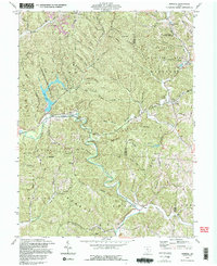
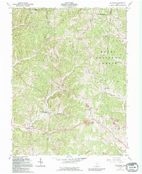 1992 Allensville1994 Print · USGSVinton County's wooded ridges and hollows are captured here in the early nineties, showing a landscape defined by small settlements and resource extraction. Researchers can locate numerous family burial grounds like Curry Cem and historical crossings including the Covered Bridge near Allensville.
 - 1992 Map of Laurelville, 1995 Print
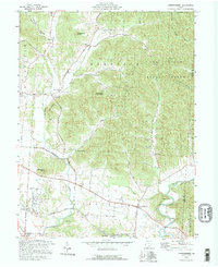
 1992 Laurelville1995 Print · USGSLaurelville and the surrounding Hocking County ridges are shown here in the mid-1990s, capturing the area's rural character and state forest boundaries. Genealogists can trace family landmarks like Schooley Cem, South Perry, and an ancient Indian Mound.
 - 1992 Map of Ratcliffburg, 1995 Print
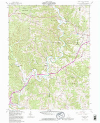
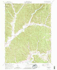 1992 Ratcliffburg1995 Print · USGSVinton County's creek valleys and forested ridges are captured in the early 1990s, reflecting a landscape defined by small townships and resource extraction. Genealogists can locate family-named sites like Slagle Farm Cem, Scotty Cem, and the old Eagle Mills.
 - 1992 Map of New Plymouth, 1995 Print
 1992 New Plymouth1995 Print · USGSThe Hocking and Vinton County borderlands in the early nineties show a landscape deeply shaped by mining and forestry. Local historians can trace family roots through sites like Millers Chapel and Ilesboro or locate expansive Reclaimed Strip Mine tracts.
 - 1992 Map of Mineral, 1995 Print
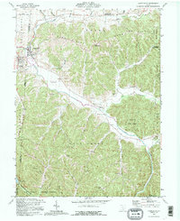
 1992 Mineral1995 Print · USGSVinton and Athens counties are shown here in the 1990s, where public forest lands and historic iron industry sites meet. Researchers can locate the Hope Furnace ruins, the Chesapeake and Ohio railroad, and numerous family cemeteries like Brooks Cem.2 unique versions available
 - 1992 Map of Hamden, 1995 Print
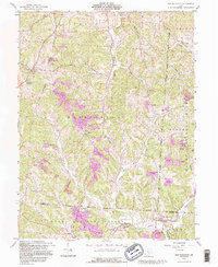
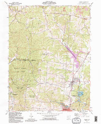 1992 Hamden1995 Print · USGSHamden and the surrounding forest lands of Vinton and Jackson Counties are shown here during a period of industrial activity and outdoor recreation. Researchers can locate family landmarks like Cassill Cem, the historic Richland Furnace, and the prominent Reed Hill Lookout Tower.
 - 1992 Map of Londonderry, 1995 Print
 1992 Londonderry1995 Print · USGSRoss County during the 1990s reveals a quiet landscape of valley settlements and upland forests. Genealogists and local historians can trace family ties at Londonderry Cem or explore small localities like Lickskillet and Tucson.
 - 1992 Map of Richmond Dale, 1995 Print
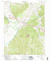 1992 Richmond Dale1995 Print · USGSSouthern Ross County appears here in the early 1990s as a land of narrow hollows and historic transit corridors. Researchers can trace the Ohio and Erie Canal, the old B & O RR line, and family sites like German Chapel Cem.
 - 1992 Map of Vales Mills, 1995 Print
 1992 Vales Mills1995 Print · USGSSoutheastern Ohio's Vinton County is captured in the early 1990s, showing a landscape defined by the winding Raccoon Creek and rural mill sites. Local researchers can trace family roots through historic burial grounds like Arbaugh Cem and Castor Cem or find early social hubs like Wilton Sch.
End of results
Showing maps 1-9 of 9
Top cities of Vinton County
- McArthur historical maps
- Richland historical maps
- Hamden historical maps
- Zaleski historical maps
- Wilkesville historical maps
Frequently asked questions
- What are the different types of historical maps available for Vinton County?
- What is the oldest map of Vinton County?
- Where can I purchase historical maps of Vinton County for my home or office?
- Where can I download high-res historical maps of Vinton County?
- Are there historical topographic maps available for Vinton County?
- Is there historical aerial imagery available for Vinton County?
- Where are historical maps of Vinton County sourced from?