1960s Maps of Clearcreek Township, Ohio
Explore 4 historic maps of Clearcreek Township from the 1960s. These maps offer a rare glimpse into what life looked like during the 1960s — showing old roads, neighborhoods, homes, and landmarks that have changed or disappeared over time.
Whether you're researching your family's past, planning a metal detecting trip, or studying how Clearcreek Township's landscape evolved across the 1960s, these high-resolution maps are a powerful tool for exploring the history of this region.
- Focus on a specific era: All maps on this page are from the 1960s, giving you a focused view of this time period.
- See what’s changed: Compare century-old streets, trails, and buildings to today's modern landscape using overlays and satellite layers.
- Research with precision: Use these maps for genealogy, historical research, land use analysis, or educational projects.
- View, download, or print: Maps are fully viewable online in high resolution, and can be downloaded or printed for your own records.
Start exploring Clearcreek Township's history through authentic maps from the 1960s. This is your window into the past.
Clearcreek Township, OH maps
(4)- 1965 Map of Franklin, 1967 Print
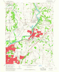 1965 Franklin1967 Print · USGSMiddletown and Franklin thrive along the river and rail corridors of the Miami Valley in the mid-1960s. Genealogists and researchers can trace local landmarks like Wood Hill Cemetery, Stettler Ch, and the sprawling Mound Laboratory (AEC) complex.5 unique versions available
 - 1965 Map of Monroe, 1967 Print
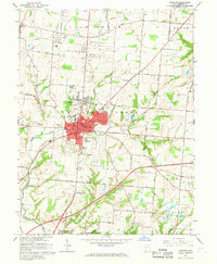
 1965 Monroe1967 Print · USGSButler and Warren Counties are seen during a period of rapid development in the mid-sixties. Local researchers can trace family roots at Mound Cemetery, locate the old Beedles Station, or study the footprint of the Lebanon Correctional Institution.5 unique versions available
 - 1965 Map of Springboro, 1967 Print
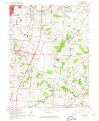
 1965 Springboro1967 Print · USGSThe Montgomery and Warren County line comes alive in the mid-sixties as Centerville and Springboro begin to expand. Researchers can trace family history through sites like Rehoboth Cem, Bethel Ch, and the crossroads at Five Points.4 unique versions available
 - 1966 Map of Lebanon, 1968 Print
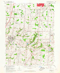
 1966 Lebanon1968 Print · USGSLebanon and the surrounding Warren County countryside are captured here in the mid-sixties, showing the transition from a traditional rail hub to a modernizing suburb. Genealogists can locate family sites at Old Stone Schoolhouse Cem, Kirby Cem, or the Bethany Ch.4 unique versions available
End of results
Showing maps 1-4 of 4
Top cities near Clearcreek Township
- Dayton historical maps
- Kettering historical maps
- Middletown historical maps
- Beavercreek historical maps
- Mason historical maps
- Trotwood historical maps
See more
Top neighborhoods of Clearcreek Township
- Red Lion historical maps
- Flat Iron historical maps
- Kenricksville historical maps
- Pekin historical maps
- Ridgeville historical maps
- Dodds historical maps
See more
Frequently asked questions
- What are the different types of historical maps available for Clearcreek Township?
- What is the oldest map of Clearcreek Township?
- Where can I purchase historical maps of Clearcreek Township for my home or office?
- Where can I download high-res historical maps of Clearcreek Township?
- Are there historical topographic maps available for Clearcreek Township?
- Is there historical aerial imagery available for Clearcreek Township?
- Where are historical maps of Clearcreek Township sourced from?