1900s (20th Century) Maps of Washington County, Ohio
Explore 74 historic maps of Washington County from the 1900s (20th Century). These maps offer a rare glimpse into what life looked like during the 1900s — showing old roads, neighborhoods, homes, and landmarks that have changed or disappeared over time.
Whether you're researching your family's past, planning a metal detecting trip, or studying how Washington County's landscape evolved across the 1900s, these high-resolution maps are a powerful tool for exploring the history of this region.
- Focus on a specific era: All maps on this page are from the 1900s, giving you a focused view of this time period.
- See what’s changed: Compare century-old streets, trails, and buildings to today's modern landscape using overlays and satellite layers.
- Research with precision: Use these maps for genealogy, historical research, land use analysis, or educational projects.
- View, download, or print: Maps are fully viewable online in high resolution, and can be downloaded or printed for your own records.
Start exploring Washington County's history through authentic maps from the 1900s. This is your window into the past.
Washington County, OH maps
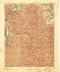
(74)- 1902 Map of Parkersburg
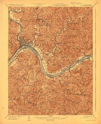
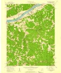
 1902 Parkersburg1902 Print · USGSThe river-and-rail corridor between Ohio and West Virginia comes alive at the dawn of the twentieth century. Researchers can trace the early footprints of Parkersburg and Vienna, the sprawling Blennerhassett Island, and the old rail lines at Belpre.
 - 1903 Map of Macksburg, 1958 Print
 1903 Macksburg1958 Print · USGSSoutheast Ohio's river valleys and rail corridors were the lifelines of Noble and Washington counties at the turn of the century. Genealogists can trace family roots through rural post offices like Germantown Saltpeter PO and rail hubs such as Macksburg and Dexter City.
 - 1904 Map of Parkersburg
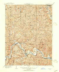
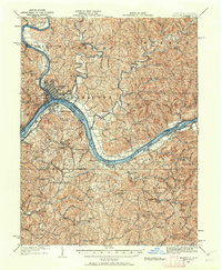
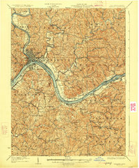
 1904 Parkersburg1904 Print · USGSThe riverfront economies of Wood County and Washington County meet at the turn of the century where the Muskingum and Ohio rivers converge. Researchers can trace the early rail networks of the Baltimore and Ohio R.R. and locate family-named settlements like Gravelbank, Center Belpre, and Vincent.5 unique versions available
 - 1904 Map of Marietta, 1923 Print
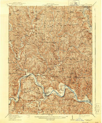
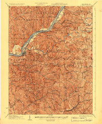
 1904 Marietta1923 Print · USGSThe riverfront communities of the Ohio Valley come to life in this early 1900s survey of the border region. Trace the historic Steamboat Route past Kerr Island or locate ancestral homes in rural Valley Mills and Stanleyville.
 - 1904 Map of Chesterhill, 1957 Print
 1904 Chesterhill1957 Print · USGSSoutheast Ohio's rugged hill country is captured here during the peak of its rail-and-river economy in the early twentieth century. Researchers can locate vanished rural post offices and community landmarks like Calvary P O, Bethany Church, and Patten Mills.
 - 1905 Map of New Matamoras, 1916 Print
 1905 New Matamoras1916 Print · USGSMonroe and Washington counties come alive in the decade after the century's turn, showing a world of river commerce and ridge-top farming. Genealogists can trace family footprints across old postal stops like Langs P.O. and Centerview P.O. or the milling sites at Rinard Mills.
 - 1905 Map of Macksburg, 1948 Print
 1905 Macksburg1948 Print · USGSSoutheastern Ohio at the turn of the century was a landscape of deep creek valleys and rising ridges connected by river and rail. Local historians can trace early post offices like Carlisle Berne P.O. and the winding P. R. R. railroad.
 - 1906 Map of Saint Marys
 1906 Saint Marys1906 Print · USGSThe riverfront around St Marys and the Ohio River islands is captured here in the early 1900s. Genealogists and researchers can trace early rural life through landmarks like Ninemile Schoolhouse, Union Mills, and the Baltimore and Ohio RR corridor.3 unique versions available
 - 1906 Map of Belleville
 1906 Belleville1906 Print · USGSWood County at the turn of the century is defined by its deep river valleys and the expansion of the Baltimore and Ohio RR. Genealogists and historians can trace late-Victorian settlements like Mineral Wells, Belleville, and the riverfront at Walkers Crossing.2 unique versions available
 - 1906 Map of Chesterhill, 1943 Print
 1906 Chesterhill1943 Print · USGSSoutheastern Ohio at the start of the century reveals a landscape of coal-mining hamlets and river valley rail lines. Genealogists and researchers can trace family landmarks like Mills School, Patten Mills, and the scattered post offices of Calvary PO and Federal.
 - 1909 Map of Caldwell, 1956 Print
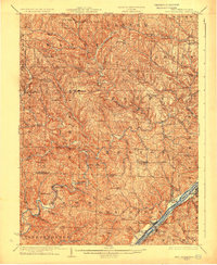
 1909 Caldwell1956 Print · USGSThe Muskingum River valley and the hills of Noble and Morgan counties are shown here in the early twentieth century. Genealogists can locate dozens of country institutions, from Bells Church and Manchester Church to the curiously named Beancatcher School and Poochville School.
 - 1912 Map of Caldwell, 1943 Print
 1912 Caldwell1943 Print · USGSSoutheast Ohio's river valleys and ridge-top settlements are captured here in the years before the Great War. Genealogists can trace family footprints across dozens of rural landmarks, from Manchester Church to the curiously named Poochville School and Valleyburg Woodgrove PO.
 - 1924 Map of Belleville, 1954 Print
 1924 Belleville1954 Print · USGSWood County’s riverfront settlements and rural school districts are captured here in the mid-twenties during the height of the rail era. Genealogists can locate long-lost family landmarks like Harris Ferry, Meldahl, and dozens of rural schoolhouses including Leafy Glen School.
 - 1924 Map of St Marys, 1956 Print
 1924 St Marys1956 Print · USGSPleasants County and the Ohio River valley are shown here in the mid-twenties, just as the local rail and river networks reached their peak. Genealogists can trace hundreds of family sites near St Marys, including Bibbys Chapel, Ellenboro, and the Willow Island School.
 - 1924 Map of New Matamoras, 1958 Print
 1924 New Matamoras1958 Print · USGSThe Ohio River borderlands are shown in detail during the mid-1920s, featuring the winding valleys of the Muskingum rivers. Genealogists can trace family locations through named schools and rural post offices like Rinard Mills, Salem Hall, and Zion Church.
 - 1924 Map of Marietta, 1962 Print
 1924 Marietta1962 Print · USGSThe Ohio River borderlands near the Muskingum confluence are captured here in the 1920s, showing a landscape of river-bend towns and hilltop farmsteads. Researchers can trace historic schools and rural meeting places like Rising Sun School, Social Chapel, and the Baltimore and Ohio RR line.
 - 1926 Map of Belleville
 1926 Belleville1926 Print · USGSThe Ohio River valley and its rugged Wood County hinterlands come into focus in the mid-twenties. Genealogists and historians can locate dozens of rural schools and churches like Leafy Glen School, Torch PO, and Serepta Church along the winding runs.2 unique versions available
 - 1926 Map of New Matamoras
 1926 New Matamoras1926 Print · USGSThe Ohio River valley and the rugged interior of Monroe County appear here in the mid-1920s. Genealogists can trace early twentieth-century rural life through numerous small post offices and schools like Cochransville Centerview PO and Excelsior School.2 unique versions available
 - 1927 Map of Marietta
 1927 Marietta1927 Print · USGSThe Mid-Ohio Valley comes alive in this mid-1920s survey of the river confluence at the Ohio River. Genealogists can trace family roots through numerous country schools and churches like Last Chance School and Shiloh Church.3 unique versions available
 - 1927 Map of Saint Marys
 1927 Saint Marys1927 Print · USGSPleasants and Ritchie counties come into focus during the mid-twenties as the Baltimore and Ohio railroad skirts the Ohio River. Researchers can trace ancestral locations through dozens of rural landmarks, from the Northwestern Turnpike to the Willow Island School and Mt Carmel Church.3 unique versions available
 - 1949 Map of Clarksburg
 1949 Clarksburg1949 Print · USGSThe upper Ohio River valley and the industrial heart of West Virginia come into focus during this post-war period. Genealogists and researchers can trace the rail corridors of the Baltimore and Ohio and locate centers like Fairmont, Grafton, and Waynesburg.
 - 1956 Map of Clarksburg, 1966 Print
 1956 Clarksburg1966 Print · USGSThe Ohio River valley and the industrial heart of West Virginia are seen here in the mid-1950s as rail and river commerce thrived. Researchers can trace historic transport lines like the Baltimore and Ohio RR and locate ancestral homes in Clarksburg, Moundsville, or Parkersburg.2 unique versions available
 - 1957 Map of Parkersburg, 1958 Print
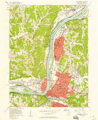 1957 Parkersburg1958 Print · USGSThe Ohio River valley at the height of its mid-century industrial era comes to life on this 1957 survey of Parkersburg and Belpre. Genealogists can locate family sites at Mt Olivet Cemetery, Cutler Chapel, or school buildings like Nash Sch and Blennerhassett Sch.
 - 1957 Map of Willow Island, 1958 Print
 1957 Willow Island1958 Print · USGSThe Ohio River valley and its industrial backcountry come into focus in the mid-1950s, showing a landscape of oil wells and river-rail transport. Trace ancestral roots at Middle Ridge Ch, Pumpkin Knob Sch, or the sprawling Volcano Oil Field.3 unique versions available
 - 1957 Map of Valley Mills, 1959 Print
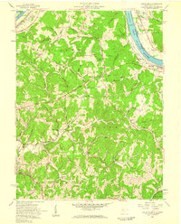 1957 Valley Mills1959 Print · USGSWood County at the Ohio River's edge during the late fifties reveals a landscape of river locks and rising ridgelands. Genealogists and researchers can trace family landmarks like Henderson Cem, the Boreman Sch, and the riverside community of Waverly.5 unique versions available
Showing maps 1-25 of 74
Top cities of Washington County
- Marietta historical maps
- Belpre historical maps
- Waterford historical maps
- Dunham historical maps
- Barlow historical maps
- Newport historical maps
See more
Frequently asked questions
- What are the different types of historical maps available for Washington County?
- What is the oldest map of Washington County?
- Where can I purchase historical maps of Washington County for my home or office?
- Where can I download high-res historical maps of Washington County?
- Are there historical topographic maps available for Washington County?
- Is there historical aerial imagery available for Washington County?
- Where are historical maps of Washington County sourced from?