1960s Maps of Stryker, Springfield Township
Explore 2 historic maps of Stryker from the 1960s. These maps offer a rare glimpse into what life looked like during the 1960s — showing old roads, neighborhoods, homes, and landmarks that have changed or disappeared over time.
Whether you're researching your family's past, planning a metal detecting trip, or studying how Stryker's landscape evolved across the 1960s, these high-resolution maps are a powerful tool for exploring the history of this region.
- Focus on a specific era: All maps on this page are from the 1960s, giving you a focused view of this time period.
- See what’s changed: Compare century-old streets, trails, and buildings to today's modern landscape using overlays and satellite layers.
- Research with precision: Use these maps for genealogy, historical research, land use analysis, or educational projects.
- View, download, or print: Maps are fully viewable online in high resolution, and can be downloaded or printed for your own records.
Start exploring Stryker's history through authentic maps from the 1960s. This is your window into the past.
Stryker, Springfield Township maps
(2)- 1960 Map of Evansport, 1961 Print
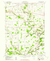 1960 Evansport1961 Print · USGSNorthwest Ohio at the dawn of the sixties shows a landscape shaped by the winding Tiffin River and the New York Central rail line. Genealogists can trace family landmarks like Evansport Cem, Oak Grove Ch, and the Township High Sch near Evansport.2 unique versions available
 - 1961 Map of West Unity, 1962 Print
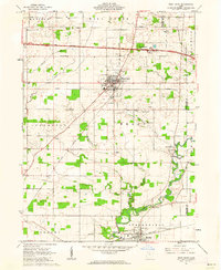 1961 West Unity1962 Print · USGSWilliams County at the start of the sixties shows a landscape defined by the Tiffin River and the new Ohio Turnpike. Researchers can trace family history at the Quaker Ch Cem or explore the rail era through West Unity and Stryker.2 unique versions available
End of results
Showing maps 1-2 of 2
Top cities near Stryker
- Defiance historical maps
- Bryan historical maps
- Archbold historical maps
- Montpelier historical maps
- Morenci historical maps
- West Unity historical maps
See more
Frequently asked questions
- What are the different types of historical maps available for Stryker?
- What is the oldest map of Stryker?
- Where can I purchase historical maps of Stryker for my home or office?
- Where can I download high-res historical maps of Stryker?
- Are there historical topographic maps available for Stryker?
- Is there historical aerial imagery available for Stryker?
- Where are historical maps of Stryker sourced from?