1900s (20th Century) Maps of Knowles, Oklahoma
Explore 5 historic maps of Knowles from the 1900s (20th Century). These maps offer a rare glimpse into what life looked like during the 1900s — showing old roads, neighborhoods, homes, and landmarks that have changed or disappeared over time.
Whether you're researching your family's past, planning a metal detecting trip, or studying how Knowles's landscape evolved across the 1900s, these high-resolution maps are a powerful tool for exploring the history of this region.
- Focus on a specific era: All maps on this page are from the 1900s, giving you a focused view of this time period.
- See what’s changed: Compare century-old streets, trails, and buildings to today's modern landscape using overlays and satellite layers.
- Research with precision: Use these maps for genealogy, historical research, land use analysis, or educational projects.
- View, download, or print: Maps are fully viewable online in high resolution, and can be downloaded or printed for your own records.
Start exploring Knowles's history through authentic maps from the 1900s. This is your window into the past.
Knowles, OK maps
(5)- 1954 Map of Perryton, 1966 Print
 1954 Perryton1966 Print · USGSThe High Plains of the Texas and Oklahoma panhandles are shown during a period of steady growth in the mid-1950s. Genealogists and researchers can trace rail history and local landmarks like Panhandle A & M College, Spurlock Chapel, and the isolated Lord Station.3 unique versions available
 - 1958 Map of Perryton
 1958 Perryton1958 Print · USGSThe Oklahoma Panhandle and Texas borderlands come alive in this mid-century survey, showing the vital rail-and-ranch economy of the High Plains. Researchers can trace historic stops along the Chicago Rock Island and Pacific and locate rural landmarks like Bethel Church and Spurlock Chapel.
 - 1970 Map of Knowles, 1972 Print
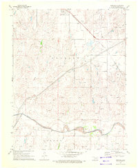 1970 Knowles1972 Print · USGSKnowles and the surrounding High Plains of Beaver County are captured here during the height of the region's energy production in the early seventies. Genealogists and historians can trace the Missouri-Kansas-Texas railroad corridor and the network of Gas Wells that dotted the landscape near the Beaver River.
 - 1970 Map of Gate NW, 1973 Print
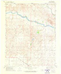 1970 Gate NW1973 Print · USGSThe Oklahoma panhandle and Kansas border come alive in 1970, showing a landscape of river bends and rail lines. Genealogists and researchers can locate the town of Knowles, the Knowles Cem, and the path of the Missouri-Kansas-Texas railroad.
 - 1986 Map of Beaver
 1986 Beaver1986 Print · USGSThe Oklahoma Panhandle is shown in the mid-eighties as a landscape of energy production and resilient prairie settlements. Trace the networks of the Oil and Gas Fields surrounding towns like Beaver, Forgan, and Turpin.2 unique versions available
End of results
Showing maps 1-5 of 5
Top cities near Knowles
Frequently asked questions
- What are the different types of historical maps available for Knowles?
- What is the oldest map of Knowles?
- Where can I purchase historical maps of Knowles for my home or office?
- Where can I download high-res historical maps of Knowles?
- Are there historical topographic maps available for Knowles?
- Is there historical aerial imagery available for Knowles?
- Where are historical maps of Knowles sourced from?