1970s Maps of Keyes, Oklahoma
Explore 2 historic maps of Keyes from the 1970s. These maps offer a rare glimpse into what life looked like during the 1970s — showing old roads, neighborhoods, homes, and landmarks that have changed or disappeared over time.
Whether you're researching your family's past, planning a metal detecting trip, or studying how Keyes's landscape evolved across the 1970s, these high-resolution maps are a powerful tool for exploring the history of this region.
- Focus on a specific era: All maps on this page are from the 1970s, giving you a focused view of this time period.
- See what’s changed: Compare century-old streets, trails, and buildings to today's modern landscape using overlays and satellite layers.
- Research with precision: Use these maps for genealogy, historical research, land use analysis, or educational projects.
- View, download, or print: Maps are fully viewable online in high resolution, and can be downloaded or printed for your own records.
Start exploring Keyes's history through authentic maps from the 1970s. This is your window into the past.
Keyes, OK maps
(2)- 1971 Map of Keyes West, 1973 Print
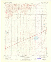 1971 Keyes West1973 Print · USGSCimarron County at the start of the 1970s shows a landscape defined by the intersection of the Atchison Topeka and Santa Fe and the Beaver Meade and Englewood railroads. Genealogists can trace the Willow Bar Cem and the settlement of Keyes alongside prominent landmarks like Castor Lake.
 - 1971 Map of Keyes East, 1973 Print
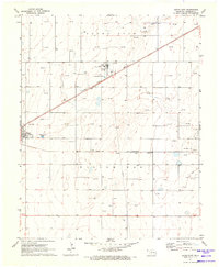 1971 Keyes East1973 Print · USGSCimarron County's high plains reveal a landscape of energy and industry in the 1970s. Researchers can trace the rail-side growth of Keyes, the operations at the Keyes Helium Plant, and the vast network of Gas Wells across Willowbar.
End of results
Showing maps 1-2 of 2
Frequently asked questions
- What are the different types of historical maps available for Keyes?
- What is the oldest map of Keyes?
- Where can I purchase historical maps of Keyes for my home or office?
- Where can I download high-res historical maps of Keyes?
- Are there historical topographic maps available for Keyes?
- Is there historical aerial imagery available for Keyes?
- Where are historical maps of Keyes sourced from?