1940s Maps of Cache Wye, Oklahoma
Explore 2 historic maps of Cache Wye from the 1940s. These maps offer a rare glimpse into what life looked like during the 1940s — showing old roads, neighborhoods, homes, and landmarks that have changed or disappeared over time.
Whether you're researching your family's past, planning a metal detecting trip, or studying how Cache Wye's landscape evolved across the 1940s, these high-resolution maps are a powerful tool for exploring the history of this region.
- Focus on a specific era: All maps on this page are from the 1940s, giving you a focused view of this time period.
- See what’s changed: Compare century-old streets, trails, and buildings to today's modern landscape using overlays and satellite layers.
- Research with precision: Use these maps for genealogy, historical research, land use analysis, or educational projects.
- View, download, or print: Maps are fully viewable online in high resolution, and can be downloaded or printed for your own records.
Start exploring Cache Wye's history through authentic maps from the 1940s. This is your window into the past.
Cache Wye, OK maps
(2)- 1942 Map of Cache
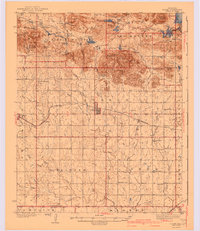 1942 Cache1942 Print · USGSComanche County during the late 1930s reveals a unique landscape where the Wichita Mountains Wildlife Refuge meets the rail-side towns of the plains. Genealogists can trace rural life through sites like Post Oak Mission, Devo Memorial Chapel, and the Spring Valley Sch.3 unique versions available
 - 1949 Map of Quanah Mountain, 1953 Print
 1949 Quanah Mountain1953 Print · USGSComanche County reveals a complex landscape of wildlife preservation and Comanche heritage just after the war. You can trace the locations of the Old Star House, Post Oak Mission, and Quanah Parker Camp alongside the granite peaks of Elk Mountain and Quanah Mountain.2 unique versions available
End of results
Showing maps 1-2 of 2
Top cities near Cache Wye
Frequently asked questions
- What are the different types of historical maps available for Cache Wye?
- What is the oldest map of Cache Wye?
- Where can I purchase historical maps of Cache Wye for my home or office?
- Where can I download high-res historical maps of Cache Wye?
- Are there historical topographic maps available for Cache Wye?
- Is there historical aerial imagery available for Cache Wye?
- Where are historical maps of Cache Wye sourced from?